Laguna Province
| Basic data | |
|---|---|
| Region : | CALABARZON |
| Capital : | Santa Cruz |
| Population : | 3,035,081 August 1, 2015 census
|
| Population density : | 1725 inhabitants per km² |
| Area : | 1,759.7 km² |
| PSGC : | 043400000 |
| Governor : | Teresita S. Lazaro |
| Official website: | Laguna |
| structure | |
| - Highly urbanized cities | 0 |
| - provincial cities | 4th |
| - municipalities | 26th |
| - Barangays | 674 |
| - electoral districts | 4th |
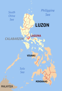
| Location of the province on the island of Luzon | |

|
|
Coordinates: 14 ° 10 ′ N , 121 ° 20 ′ E Laguna is a province of the Philippines on the island of Luzon in the CALABARZON region. The seat of the provincial government is in the municipality of Santa Cruz.
The province owes its name to the largest lake in the Philippines, the Laguna de Bay , which the province encloses halfway, for the meaning of the word see there.
The province has 3,035,081 inhabitants (August 1, 2015 census) and an area of 1,759.7 km². The average population density is 1725 people per km². Teresita S. Lazaro is the governor of the province.
geography
Laguna is southeast of Metro Manila , south of Rizal Province , west of Quezon , north of Batangas and east of Cavite .
The province covers the entire southern area of Laguna de Bay , the largest lake in the country. Near the lake is Makiling Mountain , known for its numerous hot springs that can be found all along its slopes. Near the southern border are the San Cristobal and the Banahaw , the highest mountain in the province. Both mountains have a mythological meaning for the local population. In total, about 40 rivers arise from the mountains in the province, with a total area of almost 5 square kilometers. The last rainforest areas in the province are in the Mounts-Banahaw-San-Cristobal National Park .
The Pagsajan waterfalls are well-known beyond the borders of the country, located in the middle of the jungle and can only be reached by boat. The eastern part of Laguna is from the southern foothills of the Sierra Madre spans -Gebirges, in the Lake Caliraya and Lumot Lake lie.
Population development
Development of the population since the 1990 census.
| year | population |
|---|---|
| 1990 | 1,370,232 |
| 2000 | 1,965,872 |
| 2010 | 2,669,847 |
| 2015 | 3,035,081 |
languages
The main language is Tagalog , but English is also widely used.
Political structure
Laguna is divided into 26 independently administered municipalities and 4 cities. The municipalities and cities are made up of a total of 674 barangays (districts). The province is still divided into three congressional districts .
Cities
Communities
economy
The economy of Laguna lives mainly from agricultural production. In particular, coconuts, rice, sugar cane , citrus fruits , lanzones and other agricultural products are planted in the province . The wide fields between the extensive forest areas are also ideal for growing vegetables, tropical fruits, orchids as well as various decorative flowers and exotic plants.
In addition, the province lives from its tourist attractions such as the Pagsanjan waterfall , the hot springs of Los Baños, the Makiling National Park, the Caliraya Lake. And the Laguna de Bay. The degree of economic development varies significantly. The cities near the Metro Manila have experienced a strong industrialization, while in the places away from the metropolitan connection, the focus is still on agricultural production and fishing, with agriculture-based industries and small-scale enterprises also being located.
Laguna is also endowed with various natural resources. The forests are made of bamboo, rattan and soft hardwoods. The province is also rich in mineral resources such as clay , jasper and basalt glass .
history
As already mentioned, the province of Laguna was named after the Laguna de Bay. This in turn got its name from the town of Bay , ( Laguna de Bay is Spanish and means "Lake of Bay"), the first capital of the province. In 1571 an expedition of a hundred Spanish and Mexican soldiers, accompanied by numerous native allies from the Visayas and led by Captain Juan de Salcedo , conquered the area of the present-day province and the surrounding areas for the Spanish Kingdom .
In 1577, Franciscan missionaries reached the port of Manila and began in 1578 with the Christianization of today's provincial area, as well as the areas of Morong (now the province of Rizal ), Tayabas (now Quezon ) and the entire Bicol peninsula . Juan de Placencia and Diego de Oropesa were the first Franciscans to be sent to this region. From 1580 the towns of Bay, Caliraya, Majayjay, Nagcarlán, Liliw, Pila, Santa Cruz, Lumban, Pangil and Siniloan were founded. In 1678 Fray Hernando Cabrera founded the village of San Pablo de los Montes (now San Pablo) and had a wooden church and a monastery built here, which still have a special place within the province today.
In 1670 the borders between Lucban, Majayjay and Cavite were established. The most populous city at that time was the town of Bay, which had been the provincial capital until 1688. After that, the seat of the state government was moved to Pagsanjan and later, in 1858, to Santa Cruz. In 1754 the province was divided into the new provinces of Laguna and Tayabas, with the Malinao River separating the villages of Majayjay and Lumban and since then has been the border river between the two provinces.
The province was the site of two bloody battles in the 17th century after the Chinese initiated two revolts against Spanish colonial rule. The first took place in 1603 and ended with the defeat of the Chinese invaders in the mountains of San Pablo. The second dates from 1639 when some Chinese units established themselves in the highlands of Cavinti and Lumban before surrendering after a year in Pagsanjan.
During the British invasion (1762–1764), the troops of the Spanish colonial government were supported in the defense of the country by local associations from Laguna. After the successful repulsion of the British invasion efforts, the support of the local population transformed over the years into bitter hostility towards the Spanish crown. Severe mistreatment by the colonizers, especially by the clergy , accompanied by constant intolerance towards the natives through religious rule, sparked the anger of the Laguna people. This led to a revolt in the town of Lucban in 1840, which was started under the leadership of Hermano Pule (Apolinario de la Cruz) and which the residents of the localities of Majayjay, Nagcarlán, Bay and Biñan joined.
In 1896, thousands of provincial residents once again supported the Katipunan- initiated Philippine Revolution . Laguna was one of the eight provinces in which the uprising against the Spanish colonial power spread particularly quickly. The poorly equipped revolutionaries fought against well-armed Spanish units. However, their military inferiority was offset by their number and determination, so that on August 31, 1898, the last Spanish troops had to surrender in Santa Cruz.
After the outbreak of the Philippine-American War (1899-1901), the generals Juan Cailles and Paciano Rizal organized the defense of the province of Laguna, whose surrender on June 3, 1901, however, was inevitable. Cailles was later named the first Filipino governor of Laguna Province to fly the American flag.
During the Japanese occupation of the Philippines (1942–1945), the provincial area was again a center of Filipino resistance. After the liberation of the Philippines by the allied Philippine-American armed forces began in October 1944 with the invasion of Leyte , the number of attacks by Philippine soldiers and guerrilla troops against the Japanese armed forces rose from 1945 onwards, which ultimately surrendered in September 1945.
climate
The province's climate, especially in the area west of the municipality of Santa Cruz, is relatively dry from November to April, while near the southern border it is characterized by rain for the rest of the year. Most of the parts in the eastern and southern sections of the province have no distinguishable dry or rainy season, here precipitation can occur evenly over the year.
Personalities
The following Filipino personalities come from the Laguna Province:
- Pedro Pelaez important reformer and father of the secularization movement in the Philippines
- Ambrosio Rianzares Bautista , Biñan City, lawyer and author of the Filipino Declaration of Independence of June 12, 1898
- José Rizal ( Calamba City ) - Filipino national hero
- Charice Pempengco ( Cabuyao ) - International Singer / Recording Artist
- Ronato "The Volcano" Alcano ( Calamba City ) - Professional pool player
Colleges
Attractions
- The Rizal Shrine in Calambâ City
- The Japanese Garden in Cavinti
- The Pagsajan waterfalls in Pagsanjan
- The Makiling mountain near Calamba City and Los Baños
- The Hidden Valley Springs in Calauan
- The Crocodile Lake in Los Baños
- Eight Mountains in Nagcarlán with Mt. Atimla, Mt. Mabilog, Mt. Nagcarlán, Mt. Malauban, Mt. Lansay, Mt. Bayaquitos, Mt. Cristóbal and Mt. Banahaw .
- Seven Lakes around San Pablo City with Sampaloc Lake, Lake Bunot, Lake Calibato, Lake Pandin, Lake Yambo, Lake Palakpakin and Lake Muhikap.
- The Dalitiwan River and Taytay Falls in Majayjay
- The Buruwisan waterfalls in Sinilóan
- The Pila Municipal Museum in Pila
- The Pook ni María Makiling in Los Baños
- The Hot Spring Resorts in Calamba City
Web links
Individual evidence
- ↑ Official website of Laguna ( Memento of the original from November 6, 2014 in the Internet Archive ) Info: The archive link was automatically inserted and not yet checked. Please check the original and archive link according to the instructions and then remove this notice.
- ↑ Philippines: Administrative Division (Regions and Provinces) - Population Statistics, Charts and Map. Accessed May 31, 2018 .
- ↑ Biography of José Rizal ( Memento of the original from March 5, 2010 in the Internet Archive ) Info: The archive link was inserted automatically and has not yet been checked. Please check the original and archive link according to the instructions and then remove this notice.
