Lumban
| Municipality of Lumban | ||
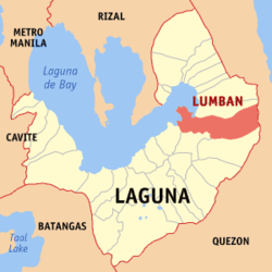
| Location of Lumban in the Laguna Province | ||
|---|---|---|

|
||
| Basic data | ||
| Region : | CALABARZON | |
| Province : | Laguna | |
| Barangays : | 18th | |
| District: | 4. Laguna District | |
| PSGC : | 043413000 | |
| Income class : | 4. Income bracket | |
| Households : | 5456 May 1, 2000 census
|
|
| Population : | 30,652 August 1, 2015 census
|
|
| Population density : | 316.7 inhabitants per km² | |
| Area : | 96.8 km² | |
| Coordinates : | 14 ° 18 ′ N , 121 ° 28 ′ E | |
| Postal code : | 4014 | |
| Area code : | +63 49 | |
| Geographical location in the Philippines | ||
|
|
||
Lumban is a Filipino community in Laguna Province, 104 kilometers southeast of Manila . It has 30,652 inhabitants (2015 census). Lumban is the fourth largest municipality in Laguna Province with an area of 96.8 square kilometers.
geography
The man -made Lake Caliraya lies on the territory of the municipality .
Barangays
Lumban is politically divided into 18 barangays , two of which are not inhabited.
|
|
|
history
Lumban is one of the oldest places in Laguna. The name is derived from the Lumbang tree. The provincial capital Santa Cruz , as well as Cavinti and Pagsanjan were once part of Lumban.
