Pagsanyan
| Municipality of Pagsanjan | ||
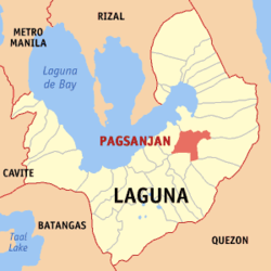
| Location of Pagsanjan in the Laguna province | ||
|---|---|---|

|
||
| Basic data | ||
| Region : | CALABARZON | |
| Province : | Laguna | |
| Barangays : | 16 | |
| District: | 4. Laguna District | |
| PSGC : | 043419000 | |
| Income class : | 3rd income bracket | |
| Households : |
May 1, 2000 census
|
|
| Population : | 42.164 August 1, 2015 census
|
|
| Population density : | 1600 inhabitants per km² | |
| Area : | 26.36 km² | |
| Coordinates : | 14 ° 16 ′ N , 121 ° 27 ′ E | |
| Postal code : | 4008 | |
| Mayor : | GIRLIE J. EJERCITO | |
| Website: | Official website of Pagsanjan | |
| Geographical location in the Philippines | ||
|
|
||
Pagsanjan is a Filipino municipality in Laguna Province , Administrative Region IV, Calabarzon. It has 42,164 inhabitants (August 1, 2015 census) who lived in 16 barangays . It is classified as a third income class community in the Philippines and as partially urbanized .
Pagsanjan's neighboring communities are Magdalena and Santa Cruz in the west, Lumban in the north, and Cavinti in the south. The topography of the city is characterized by flat , hilly and mountainous landscapes. In the east of the municipality are the famous Pagsanjan waterfalls .
The area of the parish was once a district of Lumban. In 1668 eight Chinese and Japanese merchants founded Pagsanjan, strategically located between the Balanac and Bumbungan rivers, which flow into the Laguna de Bay . On December 12, 1668, the municipality was granted city rights.
In 1812 Pedro Pelaez was born in the parish , who is considered to be the father of the secularization movement within the Roman Catholic Church in the Philippines.
Barangays
|
|
Sons and daughters of the church
- Ernesto Maceda (1935–2016), politician
