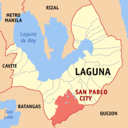
San Pablo City
| San Pablo City | ||
| Location of San Pablo City in Laguna Province | ||
|---|---|---|

|
||
| Basic data | ||
| Region : | CALABARZON | |
| Province : | Laguna | |
| Barangays : | 80 | |
| District: | 3. Laguna District | |
| PSGC : | 043424000 | |
| Income class : | 1st income bracket | |
| Households : |
May 1, 2000 census
|
|
| Population : | 266.068 August 1, 2015 census
|
|
| Population density : | 1347 inhabitants per km² | |
| Area : | 197.56 km² | |
| Coordinates : | 14 ° 5 ' N , 121 ° 18' E | |
| Postal code : | 4000 | |
| Website: | http://www.sanpablocity.com.ph/ | |
| Geographical location in the Philippines | ||
|
|
||
San Pablo City is a Filipino Component City in Laguna Province , Administrative Region IV, Calabarzon. It has 266,068 inhabitants (August 1, 2015 census) who lived in 80 barangays . It is classified as the first income class community in the Philippines and highly urbanized . The city is nicknamed the City of Seven Lakes , ( Tagalog : Lungsod ng Lawa Pitong) .
San Pablo had been part of the Roman Catholic Archdiocese of Lipa since 1910 . On November 28th, Pope Paul VI. then the new diocese of San Pablo was built, the cathedral of which is dedicated to Paulus von Thebes (Paulus the First Hermit - St. Paul the First Hermit ).
geography
San Pablo City is located in the south of the Laguna province, at the foot of the volcanoes Mount Banahaw and San Cristobal . The last great rainforests in the province extend on its mountain slopes . The Mounts-Banahaw-San-Cristobal National Park was established to protect the forest . In the north of the city lies the 1,090 meter high Makiling mountain . San Pablo City's neighboring communities are Alaminos in the northwest, Santo Tomas and Lipa City in the west, Calauan in the north, and Nagcarlan and Rizal in the east. The topography of the city is characterized by flat , hilly and mountainous landscapes.
traffic
San Pablo City is connected to the Bicol region and the metropolitan metropolitan area of Metro Manila by the Maharlika Highway and railroad . Daily rail connections are offered by the Philippine National Railways .
Barangays
|
|
|
|
