Pila (Laguna)
| Municipality of Pila | ||
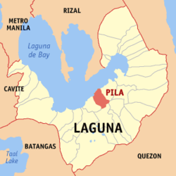
| Location of Pila in the Laguna province | ||
|---|---|---|

|
||
| Basic data | ||
| Region : | CALABARZON | |
| Province : | Laguna | |
| Barangays : | 17th | |
| District: | 4. Laguna District | |
| PSGC : | 043422000 | |
| Income class : | 3rd income bracket | |
| Households : |
May 1, 2000 census
|
|
| Population : | 50,289 August 1, 2015 census
|
|
| Population density : | 1612 inhabitants per km² | |
| Area : | 31.20 km² | |
| Coordinates : | 14 ° 14 ′ N , 121 ° 22 ′ E | |
| Postal code : | 4010 | |
| Geographical location in the Philippines | ||
|
|
||
Pila ( Tagalog : Bayan ng Pila ) is a Filipino municipality in the province of Laguna , in the administrative region IV, Calabarzon. It has 50,289 inhabitants (August 1, 2015 census) who lived in 17 barangays . It is classified as a third income class community in the Philippines and as urbanized .
Pilas neighboring communities are Victoria in the west, Nagcarlan in the south, Magdalena in the southeast and Santa Cruz in the east. In the north of the municipality is the largest lake in the Philippines, the Laguna de Bay .
Barangays
|
|

