Calamba City
|
City of Calamba Lungsod ng Calamba |
||
| Location of Calamba City in the Laguna Province | ||
|---|---|---|

|
||
| Basic data | ||
| Region : | CALABARZON | |
| Province : | Laguna | |
| Barangays : | 54 | |
| District: | 2. District of Laguna | |
| PSGC : | 043405000 | |
| Income class : | 1st income bracket | |
| Households : | 58,466 May 1, 2000 census
|
|
| Population : | 454.486 August 1, 2015 census
|
|
| Population density : | 3139 inhabitants per km² | |
| Area : | 144.80 km² | |
| Coordinates : | 14 ° 13 ′ N , 121 ° 10 ′ E | |
| Mayor : | Joaquin M. Chipeco, Jr. ( NP ) | |
| Website: | www.calambacity.gov.ph/ | |
| Geographical location in the Philippines | ||
|
|
||
Calamba City (officially: City of Calamba ; Filipino : Lungsod ng Calamba ) is a Philippine city in the province of Laguna , about 54 kilometers southeast of Manila , and 45 kilometers west of the provincial capital Santa Cruz . Calamba City is a popular tourist destination due to its hot springs . Most are located in Baranggay Pansol and Canlubang Golf and Country Club. Calamba City is also a modern industrial center in the CALABARZON region with six industrial parks. A total of 5193 companies and businesses are registered in the city.
Calamba City is the birthplace of the Filipino national hero José Rizal .
geography
Calamba City is north of the dormant Makiling Volcano and on the southern shore of Lake Laguna de Bay . The southern end of the South Luzon Expressway is in Calamba City. Due to its geographical location, the city forms the gateway to the southern provinces on Luzón . The highways following the South Luzon Expressway continue to the provinces of Batangas and Quezon . Calamba City is bordered by Cabuyao in the north, Los Baños in the east, and Santo Tomas and Talisay in Batangas Province in the south, and Tagaytay City and Silang in Cavite Province in the west.
Barangays
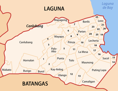
Calamba City is divided into 54 barangays .
history
The name of the city, according to legend, comes from the early days of Spanish colonization , when two soldiers from the civil guard got lost in the area now known as Calamba. The two soldiers met a local young woman who was coming from a river with a water jug. The water jug can also be found in the city seal. The Spanish soldiers asked the woman, in an authoritative tone, the name of the area they were in. The woman, who only spoke her own mother tongue, thought she was being asked what she was wearing and therefore answered extremely nervously "kalan-banga", which means something like wood stove ( kalan ) and water jug ( banga ). This legend is immortalized by a large concrete water jug erected on the city plaza ; it was completed in 1939. The jug was labeled with the names of the city's barangays. Before Calamba became an independent community on August 28, 1742, it was part of Tabuco, now Cabuyao.
In the Calamba massacre on February 1, 1945, 2,000 or more civilians were killed by the Japanese army in Calamba. In 2000, construction and teaching began at the Colegio de San Juan de Letran Calamba , a branch of the Dominican school in Intramuros .
With the passing of Republic Act No. 9024 on April 7, 2001 and the approval of the population in a referendum, Calamba was elevated from a municipality to a component city . Calamba is the second city after San Pablo in the Laguna province.
Demographic development
According to the census of May 1, 2000, Calamba had 281,146 inhabitants with an annual population growth rate of 5.5%. For 2004 the population is estimated at 348,422. Of the 54 barangays, 34 are classified as urban and 20 as rural. Baranggay IV has the highest population density with 682 inhabitants per hectare .
Town twinning
Since 2008 Calamba has been a twin town of the municipality of Wilhelmsfeld in Baden-Württemberg .

