
Marinduque
 |
|
| Basic data | |
|---|---|
| Region : | MIMAROPA |
| Capital : | Boac |
| Population : | 234,521 August 1, 2015 census
|
| Population density : | 246 inhabitants per km² |
| Area : | 952.6 km² |
| PSGC : | 174000000 |
| Governor : | Carmencita Reyes |
| Official website: | www.marinduque.gov.ph |
| structure | |
| - Highly urbanized cities | 0 |
| - provincial cities | 0 |
| - municipalities | 6th |
| - Barangays | 218 |
| - electoral districts | 1 |
| Location of Marinduque in the Philippines | |

|
|
Coordinates: 13 ° 24 ' N , 122 ° 0' E
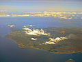
Marinduque is an island province in the Philippines in the MIMAROPA region .
The province has 234,521 inhabitants (2015 census). Marinduque has an area of 952.6 km², besides the main island that gives it its name, it also includes several smaller islands and reaches a height of 1157 m on the active Malindig volcano . It belongs to the Luzon archipelago within the Philippines . The Marinduque Wildlife Sanctuary was established on the island to protect biodiversity .
It is located south of Luzon , east of Mindoro and north of the Romblones . In the northwest it borders on the Bay of Tayabas , in the northeast on the Mompog Passage and the Bondoc Peninsula , in the south on the Tablas Strait and in the east on the Sibuyan Sea .
Boroughs
There are a total of 6 municipalities on the island:
photos

Marinduque in southern Luzon
North

south


Web links
Individual evidence