Tawi-Tawi
Coordinates: 5 ° 1 ' N , 119 ° 53' E
Tawi-Tawi is a group of islands and a province in the Philippines , which politically belongs to the Muslim Mindanao Autonomous Region (ARMM).
It is the southernmost province in the country. The capital of Tawi-Tawi is Panglima Sugala , the administrative seat is the neighboring Bongao .
Demographics
Most of the people in Tawi-Tawi either belong to the Sama speakers, of whom the Bajau (also Sama Dilaut , "Sama of the sea") form a subgroup, or to the Tausūg . Most of the people trade with Sabah on a daily basis because of the short distance .
language
The predominant language is the local Bahasa Sinama, which is widely used, with accents and displacements. This variety led to the development of its own Sinama dialect. The important dialects are Sinama Sibutu (spoken mainly in the Sibutu-Sitangkai region), Sinama Simunul (concentrated on the Simunul-Manuk-Mangkaw Islands), Sinama Kapoan (spoken in the southern Ubian-Tanduba Islands and in the region of Sapa -Sapa) and Sinama Banguingui (concentrated on Buan Island and spoken by the Banguingui people).
The Tausug language is also spoken, including English and Filipino ( Tagalog ). Many locals also speak Malay and the closely related Indonesian .
economy
Agriculture, fishing and harvesting agar are the predominant forms of economy for the people of Tawi-Tawi. Many of them work as traders. Copra is the most important product in the agricultural sector, followed by root crops, fruits and vegetables. Mindanao State University is a major educational institution .
geography
Politically
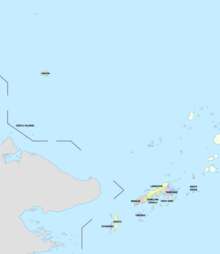
Tawi-Tawi is divided into eleven communities ( municipalities ).
- Bongao is a microcosm of religious and cultural diversity.
- Languyan
- Mapun (Cagayan De Tawi-Tawi)
- Panglima Sugala (Balimbing)
- Sapa-Sapa
- Simunul - site of the oldest mosque in the Philippines and home of the respected Sheikh Makdum, one of the early pioneers in the spread of Islam.
- Sitangkai - "Venice of the South"
- South Ubian
- Tandubas
- Turtle Islands
- Sibutu
The eleventh community, Sibutu, was established on October 21 , 2006 from the 16 barangays of the Sitangkai community, which are located on the island of Sibutu .
Most of the places are on the islands of the Sulu Archipelago . The island of Cagayan de Tawi-Tawi and the small archipelago of Turtle Islands are located in the Sulu Sea . The parishes are also divided into 203 barangays .
Physically
Tawi-Tawi is located in the southwest corner of the island state of the Philippines. To the northeast lies the Sulu province and to the west the state of Sabah of Malaysia . Tawi-Tawi also contains some islands of the Sulu Sea in the northwest, the island of Cagayan de Tawi-Tawi is about 295 km and the Turtle Islands about 270 km from the main island.
Unusually in shape, with patches of white sandy beaches and rocky bays, the province has 107 islands with a total area of around 1250 km².
climate
The province has two seasons, the dry season and the rainy season. The climate is generally temperate. The wettest phase is between August and November. The other months are generally dry with the occasional rain shower.
history
Tawi-Tawi used to be part of the Sultanate of Sulu .
During the Second World War there was a Japanese naval base here.
On September 11, 1973, the new Tawi-Tawi Province was officially established by Presidential Decree No. 302 and separated from Sulu. The seat of the provincial government was established in Bongao Township .
The name Tawi-Tawi is a projection of the Malay word jaui , which means "distant" or "far". Prehistoric travelers from mainland Asia would have repeated the word (as is customary in the Malay languages in plural or amplification) to imply that one was "far, far away" from mainland Asia.
Web links
- WOW Philippines - Tawi-Tawi ( Memento from January 18, 2016 in the Internet Archive )

