
Davao region
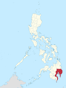
Davao Region or Region XI is a region of the Philippines . The provinces that are subordinate to it are all located in the southeast of the island of Mindanao .
The Davao region includes five provinces : Davao del Norte , Davao del Sur , Davao de Oro , Davao Occidental and Davao Oriental . The industrial, cultural and economic center is the city of Davao City .
Geographically, the region covers almost the entire Gulf of Davao .
Many companies in the IT sector have established themselves in the area around the Gulf of Davao . Because of this, the region is nicknamed Silicon Gulf .
geography
The region is bounded by the provinces of Surigao del Sur and Agusan del Norte in the north, the Philippine Sea in the east, the Gulf of Davao and the Celebes Sea in the south, and by the provinces of Agusan del Sur , Bukidnon , Cotabato and Sultan Kudarat in the west.
The topography of the region is characterized on the one hand by high mountains, mostly of volcanic origin, and mountain ranges, while on the other, wide plains extend, which are inconsistently interrupted by plateaus and followed by areas with swamps and plains .
In the north of the region rises the Diwata mountain range . It is rugged and has various mountain peaks that protrude between 900 m and 2500 m above sea level. The highest mountain is Mt. Kampalili in the southern part of the mountain range.
The Mindanao Central Cordillera, another mountain range, extends for a length of 390 km in north-south direction between Davao del Sur and the eastern part of South Cotabato . The Apo (with a height of 2965 m) is the highest mountain in Mindanao and is located in the southern part of this mountain range in the province of Cotabato .
Along the coasts, especially in the Davao Oriental province , there are extensive mangrove forests and extensive marshland. About 60% of the area of the region is covered with forest.
The region is also crossed by numerous rivers. One of the largest is the Davao River .
The Davao region covers a total area of 20,358 km².
Demographics and language
4,893,318 people live in the region (as of 2015). The average population density is 320.6 people per km² (as of 2010).
The majority of the inhabitants immigrated from the neighboring islands of the Visayas , from Luzon and Iloilo in earlier times . There are also descendants of the ethnic groups Manobos, Bagobos, Maiisakas, Maguindanon, T'boli, Tirurays and a few Muslims.
The most commonly spoken dialect is Cebuano , but Davaoeño, Visaya, Mandayan, Dibabawon, Mansakan and Manobo are also represented. The languages Filipino and English are taught in schools and are therefore also common in the region.
economy

While the region's economy is based on agriculture, it is slowly becoming a center of industrial manufacturing, trade, and tourism. With the agricultural products rice , wheat , abacá , raimi and coffee on the one hand and fruits such as bananas , pineapple and durian on the other, the district is one of the main agricultural producers in the Philippines. Its geographical position provides a connection to the markets in Malaysia , Brunei and Indonesia .
The Gulf of Davao with its abundant fishing grounds and abundance of milk fish , tuna , shrimp and crabs , is an important source of income for the coastal regions. Five of the Philippines' main fishing grounds are on the coasts of the Davao region. In brackish water of river mouths also freshwater fish such as catfish and tilapia bred and sold.
Together with the extensive forest areas and arable land, the provinces in the region also have abundant deposits of mineral resources such as copper , silver , gold , manganese , iron , nickel and other non-metallic minerals.
Administrative division
The region is divided into five provinces and the province-free city of Davao City . A total of 43 independent municipalities and 5 provincial towns (component cities) belong to the region.
These are in turn divided into a total of 1160 barangays (districts). The region consists of a total of eleven congress districts.
| province | Capital | Population (2007) |
Area ( km² ) |
Inhabitants per km² |
|---|---|---|---|---|
| Davao del Norte | Tagum City | 847.440 | 3,462.82 | 244.7 |
| Davao del Sur | Digos City | 822.406 | 3,934.01 | 209 |
| Davao de Oro | Nabunturan | 637.366 | 4,666.93 | 136.6 |
| Davao Occidental | Malita | * | * | * |
| Davao Oriental | Mati City | 486.104 | 5,164.46 | 94.1 |
| Davao City | Davao City | 1,363,337 | 2,443.61 | 558 |
* created in 2013
Cities
| Cities | province | Population (2007) |
Area ( km² ) |
Inhabitants per km² |
|---|---|---|---|---|
| Digos City | Davao del Sur | 145,514 | 287.1 | 507 |
| Island Garden City of Samal | Davao del Norte | 90.291 | 301.3 | 300 |
| Mati City | Davao Oriental | 122.046 | ||
| Panabo City | Davao del Norte | 154,329 | 259.74 | 594 |
| Tagum City | Davao del Norte | 215.967 | 192 | 1,124.8 |
Colleges
history
When the Spaniards first visited the Davao area in 1528, they found a multitude of thriving communities of various ethnic groups, such as the Bagobos, Mandayas, B'laans and Manobos. The Manobos mainly occupied the area of today's Davao del Norte , while the Bagobo groups settled in the northern part of what is now Davao del Sur .
Some time later, Islam came to the region and the locals were subsequently referred to by the Spaniards as Moros or Moore.
The modern history of Davao began in the mid-19th century when the Spanish put down a Moroz rebellion and established a Roman Catholic settlement on the strategic banks of the Davao River . Through these settlements, the Spanish occupiers gained influence over the flourishing and lucrative trade in the region, while they were unable to gain complete control over many parts of Mindanao .
The American occupation of Davao began right after the Spanish defeat in the Spanish-American War in 1898.
In 1941, during the Second World War , the Japanese troops occupied Davao and set up a regional headquarters for the imperial army here . The city of Davao City, like the region, was fiercely contested when it was liberated by American troops in 1945 and was largely destroyed.
On May 8, 1967, the Republic Act No. 4867, signed by President Ferdinand Marcos , divided the then large province of Davao into the provinces of Davao del Norte , Davao del Sur and Davao Oriental .
On September 24, 1972, the then Region XI (Southern Mindanao) was established by Presidential Decree No. 1 as part of the Integral Reorganization Plan, which included the aforementioned provinces plus the provinces Cotabato and South Cotabato as well as the city of Davao City . At that time, Davao de Oro was still part of Davao del Norte .
On July 7, 1975, Maguindanao , Cotabato and Sultan Kudarat were removed from the province by Presidential Decree No. 742 and the province of Surigao del Sur joined the region.
With Republic Act No. 7225, ratified on March 16, 1992, the Sarangani Province was separated from South Cotabato .
Republic Act No. 7901, signed by President Fidel Ramos on February 3, 1995 , assigned the province of Surigao del Sur to the newly established Caraga District , Region XIII. With the same resolution, the Sultan Kudarat Province joined Region XI, but left again in 1997.
On September 19, 2001, the regions and provinces of Mindanao were completely reorganized by President Gloria Macapagal-Arroyo with Executive Order No. 36. With this decision was u. a. politically formed the district SOCCSKSARGEN and assigned the provinces of South Cotabato and Sarangani to it. At the same time, the Southern Mindanao region was renamed the Davao Region by the same resolution .
climate
Region XI belongs to climatic categories 3 and 4, which means that there is no annual dry or rainy season in the area.
Rainfalls can occur here all year round. However, the northern monsoon rains increase the intensity of precipitation in December and January. The average rainfall is between 836 mm and 4,480 mm.
The temperatures fluctuate around an average of 26 ° C. The humidity varies between 76% and 90%.
The region lies outside the typhoon belt, which means that the provinces are largely spared from violent storms.
Attractions
- The Barcelo Pearl Farm Beach Resort
- The island Samal Iceland
- The Tudaya Falls in Davao del Sur
- The islands of Olanivan and Balut Island
- The Philippine Eagle Research and Nature Center in Davao del Sur
- The 17th Century Caraga Church in Davao Oriental
- The Aliwagwag Falls in Davao Oriental
- The Tagbibinta Falls in Davao de Oro
- The Kumaykay Falls in Davao de Oro
- The Mount Apo Natural Park
- The diving areas in the Pujada Bay Protected Seascape , the Mabini Protected Landscape and Seascape and the Baganga Bay Protected Landscape and Seascape
- The Hamiguitan with the dwarf tree forest
- The hot springs in the Mainit Hotspring Protected Landscape nature park
Web links
- About Davao
- Recent history of Region XI ( Memento of February 14, 2008 in the Internet Archive )
Individual evidence
- ↑ 2015 Population Counts Summary. In: psa.gov.ph. Retrieved June 4, 2016 .
Coordinates: 7 ° 5 ' N , 125 ° 35' E