Shariff Kabunsuan
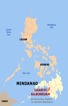
Shariff Kabunsuan was a province of the Philippines , which was formed from 2006 to 2008 from ten municipalities ( English Municipality , filipino : Bayan ) of the former first congress district of Maguindanao Province . It was the 80th province in the Philippines and the sixth in the ARMM ( Autonomous Region in Muslim Mindanao ) district until the Supreme Court invalidated the ARMM's declaration. The provincial government was located in Datu Odin Sinsuat Municipality .
geography
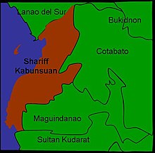
Shariff Kabunsuan bordered Lanao del Sur in the north, Cotabato in the east, Maguindanao in the southeast and Sultan Kudarat with its southern tip . To the west is the Gulf of Moro .
The province enclosed the urban area of Cotabato City , but the city itself was independent of the province and politically belonged to the district SOCCSKSARGEN .
Most of the area of the former Shariff Kabunsuan province is mountainous, with the exception of the area around Cotabato City at the mouth of the Mindanao River, as the Rio Grande de Mindanao is called on its lower reaches.
Demographics and language
According to the 2000 census , Shariff Kabunsuan had 365,848 people.
The Muslim-oriented ethnic group of the Maguindanaons makes up the majority of the provincial population. In contrast, 60% of the inhabitants of Cotabato City belong to the Christian religious communities. Other ethnic groups and communities are the Tituray, the T'boli and the Manobo.
The most common dialects are Maguindanaoan and Cebuano .
economy
The Maguindanaons in Shariff Kabunsuan who live in the river plains of the provincial country are traditionally rice farmers. In addition to rice , wheat and coconut are also grown in the region .
The Mindanao River, with its wide river delta and its numerous brackish ponds, serves as a source of drinking water and is a resort for numerous species of river fish. The sea fish is caught in Illana Bay and distributed in Cotabato City markets. The port of Polloc, 26 km north of the city, is also the most important port in the region.
Along the coast there are traders as well as fishermen. They sell handicraft products such as hand-woven malongs, a traditional dress, as well as mats and baskets.
Administrative division
Shariff Kabunsuan was divided into eleven independently administered municipalities.
These communities in turn were subdivided into a total of 209 barangays (districts).
The province belonged to a congress district .
|
climate
The climatic conditions are characterized by more or less heavy rainfall, which can occur all year round.
Compared to other provinces in the country, Shariff Kabunsuan has a low number of overcast or cloudy days.
history
The province is named after Shariff Mohammed Kabungsuwan from Johore , an Arab-Malay Islamic priest who founded the Sultanate of Maguindanao at the end of the 15th century and spread Islam in the region.
In 2006, voters from 29 municipalities in Maguindanao decided to support the establishment of the new Shariff Kabunsuan Province. Of the 500,000 registered voters, 285,372 favored the new province, only 8,802 voted against.
When it was founded on October 28, 2006, Shariff Kabunsuan Province was the 80th Province in the Philippines.
It was the first province that was not appointed by the Philippine Congress , but solely by a resolution, the Muslim Mindanao Autonomy Act No. 201, which sprang from the autonomous government of the ARMM. In 2008, the Supreme Court invalidated the creation as only Congress but not the ARMM can appoint new provinces.
Individual evidence
- ↑ William B. Depasupil: Shariff Kabunsuan a province no more. (No longer available online.) In: The Manila Times. July 18, 2008, archived from the original on April 1, 2009 ; accessed on June 22, 2009 . Info: The archive link was inserted automatically and has not yet been checked. Please check the original and archive link according to the instructions and then remove this notice.
Web links
- COMELEC Resolution No. 7727, Plebiscite to ratify the creation of the Province of Shariff Kabunsuan (PDF; 82 kB)
- Press release on Shariff Kabunsuan Province
- 'Mr shut up' Dilangalen is back in the race
Coordinates: 7 ° 11 ' N , 124 ° 10' E

