Upi (Maguindanao)
| Municipality of Upi | ||
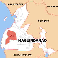
| Location of Upi in the province of Maguindanao | ||
|---|---|---|

|
||
| Basic data | ||
| Region : | Autonomous Region in Muslim Mindanao | |
| Province : | Maguindanao | |
| Barangays : | 23 | |
| District: | 1. District of Maguindanao | |
| PSGC : | 153815000 | |
| Income class : | 1st income bracket | |
| Households : | 9975 May 1, 2000 census
|
|
| Population : | 53,583 August 1, 2015 census
|
|
| Population density : | 72.1 inhabitants per km² | |
| Area : | 742.95 km² | |
| Coordinates : | 6 ° 57 ' N , 124 ° 5' E | |
| Mayor : | Ramon A. Diang Sr. | |
| Geographical location in the Philippines | ||
|
|
||
Upi is a Philippine municipality in the province of Maguindanao . It has 53,583 inhabitants (August 1, 2015 census).
Barangays
Upi is politically divided into 23 barangays .
|
|
|
