Ampatuan
| Municipality of Ampatuan | ||
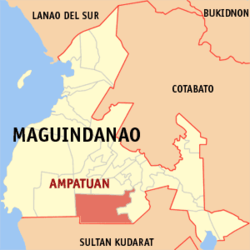
| Location of Ampatuan in the Maguindanao Province | ||
|---|---|---|

|
||
| Basic data | ||
| Region : | Autonomous Region in Muslim Mindanao | |
| Province : | Maguindanao | |
| Barangays : | 11 | |
| District: | 2. District of Maguindanao | |
| PSGC : | 153801000 | |
| Income class : | 4. Income bracket | |
| Households : | 6453 May 1, 2000 census
|
|
| Population : | 24,801 August 1, 2015 census
|
|
| Population density : | 84.8 inhabitants per km² | |
| Area : | 292.48 km² | |
| Coordinates : | 6 ° 52 ' N , 124 ° 26' E | |
| Postal code : | 9609 | |
| Geographical location in the Philippines | ||
|
|
||
Ampatuan is a Philippine municipality in the province of Maguindanao .
Adjacent communities are Datu Abdullah Sangki in the east, Shariff Aguak and Talayan in the north, South Upi in the west and Esperanza ( Sultan Kudarat Province ) in the south.
Barangays
Ampatuan is politically divided into eleven barangays .
- Dicalongan (Pob.)
- Kakal
- Kamasi
- Kapinpilan
- Kauran
- Malatimon
- Matagabong
- Saniag
- Tomicor
- Tubak
- Salman
history
In 2004 ten barangays, which previously belonged to the municipality of Ampatuan, were incorporated into the municipality of Datu Abdullah Sangki .
swell
- Page no longer available , search in web archives: National Statistics Office, Republic of the Philippines: Final Result - 2010 Census of Population
- National Statistical Coordination Board
Individual evidence
- ↑ National Statistical Coordination Board: 2004 Factsheet (January to July 2004) . August 22, 2004. Retrieved June 24, 2006.
