
Cebu
| Cebu | ||
|---|---|---|
| Waters | Pacific Ocean | |
| Archipelago | Philippines | |
| Geographical location | 10 ° 26 ' N , 123 ° 48' E | |
|
||
| surface | 4th 468 km² | |
| Residents | 4,632,359 (May 1, 2015) 1037 inhabitants / km² |
|
| main place | Cebu City | |
 |
||

Cebu ([ sɛˈbu ], Cebuano : Sugbo [ sugˈbɔ ]) is an island of the Visayas group in the island nation of the Philippines .
The island of Cebu has an area of 4,468 km²; their capital is Cebu City . In Cebu there is an annual mean temperature of 26 ° C. High humidity and temperatures around 30 ° C are typical during the day. The coolest month is January, the hottest month is May. The island is located in the zone of regularly occurring tropical cyclones.
Cebu together with some other smaller islands, the province of Cebu in the Region of Central Visayas .
geography

The island stretches for 220 km almost in a north-south direction; at its widest point it measures about 40 km. It is surrounded by many larger neighboring islands: in the southeast, across the Strait of Cebu (Bohol Strait), is Bohol , in the east Pacijan (and the rest of the Camotes Islands ), in the northeast Leyte , in the northwest Bantayan -, Kinatarkan -, Hilantagaan Iceland . Beyond the Tanon Strait , Negros in the west and in the south of Sumilon and Siquijor .
The island is traversed by an average of 600 to 800 meters high mountains. The highest mountain on the island is Osmeña Peak . It is located in the southwest of the island in the area of the municipality of Dalaguete and has an altitude of 1013 meters. The Top of the Hills viewpoint with a height of 650 meters is located in the Busay Hills, right next to Cebu City. A flat hilly landscape stretches from Mandaue City to Liloan ; There are some lagoon-like bays in it , such as the Silot Bay , which are filled with brackish water and offer a special habitat for mangrove forests .
Cebu is bounded in the north by the Visayas Sea and in the east by the Camotes Sea . Immediately off the east coast, at the level of the capital Cebu City, lies the small island of Mactan and the Olango Archipelago, both of which are part of the Danajon reef system .

Mactan-Cebu Airport, an international airport in the Visayas region, is located in Lapu-Lapu City on the island of Mactan east of Cebu .
Population development
Development of the population since the 1990 census.
| year | population |
|---|---|
| 1990 | 2,646,517 |
| 2000 | 3,356,137 |
| 2010 | 4,167,320 |
| 2015 | 4,632,359 |
language
Cebuano , which is predominant on the island of Cebu, is also called "Visayan" after the Visayas archipelago. The lingua franca in the Philippines is Tagalog ; The official and business language is English. To prepare the children for the English language, lessons are held in English from the start. Due to the long rule of the Spaniards over about three centuries, almost all dialects are interspersed with Spanish words. Some older Filipinos are still fluent in Spanish today.
history
The region was settled 25,000 years ago when the islands there were a more contiguous area. It was not until the end of the Ice Age around 10,000 - 12,000 years ago that the sea level rose so much that new islands were formed.
Around 1300 immigrants from Borneo brought Islam.
On April 7, 1521, Magellan landed on Cebu. He converted the local ruler, Raja Humabon, to Christianity. With this began the Christianization of South-East Asia.
From 1565 to 1571, Cebu was considered the capital of the Spanish colony there. On May 8, 1565, the construction of the fortress Fuerza de San Pedro began . In the 17th century the wooden fortress was renewed with stone fortifications.
Attractions
In Cebu City is the Magellan's Cross, the place from which the Christian missionary work in the Philippines started, the fortress Fuerza de San Pedro , a Daoist temple and the Basilica del Santo Niño .
The nearby eastern island of Mactan is connected to Cebu City by two bridges and has numerous beaches. The circumnavigator Ferdinand Magellan found his death there. He was defeated there by the tribal chief of the island of Mactan, Lapu-Lapu , when the people of Mactan under Lapu-Lapu's leadership did not want to bow to the supremacy of the whites and the subordination of the Cebuan prince and Magellan therefore started a conquest expedition from Cebu next door to Mactan Island. At the point of his death near Punta Engano, in the “Mactan Shrine” there is a monument to Ferdinand Magellan, the so-called “Magellan Marker”, as well as a statue of the victorious chief Lapu-Lapu. The church Patrocinio de Maria in Boljoon is since 2006 on the proposed list of the Philippines for the containment, World Heritage of UNESCO .
Lapu-Lapu is also the name of a town on the island of Mactan . Mactan is also home to the international airport for Cebu, the second busiest in the Philippines. Several luxury hotels can be found on the northeast coast of Mactan.
In Moalboal on the southwest coast and on the offshore island of Malapascua in the north of Cebu there are beaches, resorts and diving centers of great tourist interest. Malapascua can thresher sharks are observed. The Central Cebu Protected Landscape in the center of the island is home to many endemic species. Other national parks are the Guadalupe Mabugnao Mainit Hot Spring National Park and the Sudlon National Park . The Gilutongan Marine Sanctuary is located near Cebu City .
Aguinid Falls in Samboan (Samboan Waterfalls) and Mantayupan Waterfall .
The Ayala Mall in Cebu is one of the largest and most modern shopping centers in Cebu City. It houses a large number of shops with branded goods as well as restaurants with Asian and European dishes. It also has a well-developed cinema and well-kept parks.
economy
Rice , sugar and grains are the traditional agricultural products of Cebu. Copper , gold , silver and molybdenum occur as mineral resources.
With its high economic growth, Cebu City is one of the up-and-coming centers in Southeast Asia. Economic stimuli come primarily from the IT sector and tourism. Special business areas promote exports and, like the newly emerging IT parks, grant extensive tax exemption in order to attract foreign investors to the region. Foreign investments are mainly attracted by the wage cost advantages and the good level of education. The English language skills of large sections of the population are of particular importance, as a result of which Cebu is visited by many language students, mainly South Koreans. The main tourist flows come from the USA , Korea and Japan .
Near Naga, ten kilometers southwest of Cebu City, there is a large cement plant that belongs to the Mexican group ( CEMEX ).
Educational institutions
Cities
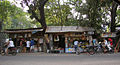
Street scene, sari sari store

Cebu Business Park

Magellan's Cross


See also
Individual evidence
- ↑ Census May 1, 2010 ( Memento of the original from April 4, 2015 in the Internet Archive ) Info: The archive link was inserted automatically and has not yet been checked. Please check the original and archive link according to the instructions and then remove this notice. , Sum of Cebu (excluding Cebu City, Lapu-Lapu City and Mandaue City) , Cebu City , Lapu-Lapu City and Mandaue City
- ↑ Mactan-Cebu Airport (CEB)
- ↑ Philippines: Administrative Division (Regions and Provinces) - Population Statistics, Charts and Map. Accessed May 31, 2018 .
- ↑ a b c d History of Cebu Philippines - Lapu-Lapu - Magellan's death
- ↑ Travel way back to 1565: Fuerza de San Pedro
Web links
- Extensive collection of images by category
- Official site of Cebu
- Mactan-Cebu International Airport (Homepage)
- Side of Naga City Cebu