Poro (island)
| Poro (island) | ||
|---|---|---|
| Waters | Lake Camotes | |
| Archipelago | Camotes Islands | |
| Geographical location | 10 ° 40 ′ N , 124 ° 27 ′ E | |
|
|
||
| length | 20 km | |
| width | 15 km | |
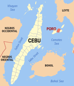
| Location of the island of Poro - the municipality of Poro on the western part of the island is marked | ||
Poro is a Philippine island in the province of Cebu .
It belongs to the group of the Camotes Islands in the north of the Camotes Sea and lies between the islands of Cebu and Leyte . In the south is the island of Bohol .
Poro measures almost 20 km in east-west and 15 km in north-south direction.
It was connected to the neighboring island of Pacijan in the immediate west by a bridge over 100 years ago; today only a narrow arm of the sea separates the two islands. In the northeast is the island of Ponson .
There are two municipalities on Poro: Poro of the same name and Tudela , whose main settlement areas are both on the south coast of the island.
The name of the island is derived from the Warayan word puro , which means island.
Only in the settlement of Poro is the language Porohanon - or Camotes Visayan - spoken, which is very similar to Cebuano .

