Malapascua
| Malapascua | ||
|---|---|---|
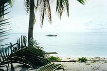
| Aerial view | ||
| Waters | Visayas lake | |
| Geographical location | 11 ° 20 '8 " N , 124 ° 6' 56" E | |
|
|
||
| length | 2 km | |
| width | 800 m | |
| Residents | 5000 | |
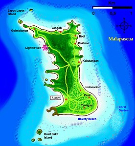
| Map of the island | ||

Malapascua is a Filipino island in the Visayas Sea .
It is located about eight kilometers northeast of the island of Cebu and administratively belongs to the province of Cebu. Its length is about two kilometers (north-south), the width about 800 meters. Malapascua is a coral island with many coral sand beaches and limestone cliffs , most of which are found on the west side of the island.
The island has around 5000 inhabitants. The Barangay Logon consists of nine villages: Logon (capital), Tawigan, Pasil, Indonacion, Kabatangan, Bakhaw, Bool, Langob and Guimbitayan.
The population lives mainly from fishing and increasingly from tourism . There is no industry to speak of on the island, but it does have its own elementary school and high school .
For some years now, the island has been increasingly developed by tourism, with more beach resorts and diving schools being built every year . Especially popular are diving to the nearby island Gato, which under conservation stands, with the particularity of an underwater cave and one running under the island underwater tunnel, and dives for "Sunken Iceland" where thresher sharks (Thresher Sharks) and good luck also manta rays and hammerhead sharks observed can be.
The administrative city for Malapascua is Daanbantayan on the main island of Cebu.
The approach to Malapascua is via Cebu City (Northern Bus Terminal), from there it is about a four-hour journey by bus or taxi to the northeast tip of Cebu in Maya. In Maya you can take a banka (pump boat) to cross over to Malapascua in half an hour.


