Liloan (Cebu)
| Municipality of Liloan | ||
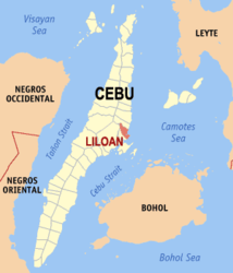
| Location of Liloan in the province of Cebu | ||
|---|---|---|

|
||
| Basic data | ||
| Region : | Central Visayas | |
| Province : | Cebu | |
| Barangays : | 14th | |
| District: | 5. District of Cebu | |
| PSGC : | 072227000 | |
| Income class : | 1st income bracket | |
| Households : |
May 1, 2000 census
|
|
| Population : | 118,753 August 1, 2015 census
|
|
| Population density : | 2586 inhabitants per km² | |
| Area : | 45.92 km² | |
| Coordinates : | 10 ° 24 ' N , 124 ° 0' E | |
| Postal code : | 6002 | |
| Geographical location in the Philippines | ||
|
|
||
Liloan is a metropolitan municipality in the Province of Cebu , on the island of Cebu , in the Philippines . It has 118,753 inhabitants (August 1, 2015 census) who live in 14 barangays . She belongs to the first income bracket of the communities in the Philippines and is described as urban .
The name of the community Liloan comes from a natural phenomenon. In the interior of the municipality there is a flat lake landscape. When the tide sets in, the water penetrates the lakes through small channels and thus ensures an exchange of water in the shallow lagoons . When the water recedes during low tide , most of the water remains in the shallow waters and the channels dry out. This process is called Lilo in Cebuano and can be observed in Silot Bay .
geography
Liloan is located on the east coast of the island of Cebu on the Camotes Sea . Cebu City is approx. 24 km southeast of the municipality and can be reached from there via the coastal road. The neighboring communities are Compostela in the north, Cebu City in the east and Consolacion in the south.
Barangays
|
|
|

