Bantayan (Cebu)
| Municipality of Bantayan | ||
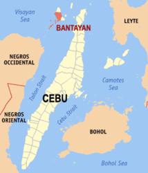
| Location of Bantayan in the province of Cebu | ||
|---|---|---|

|
||
| Basic data | ||
| Region : | Central Visayas | |
| Province : | Cebu | |
| Barangays : | 25th | |
| District: | 4. District of Cebu | |
| PSGC : | 072209000 | |
| Income class : | 1st income bracket | |
| Households : |
May 1, 2000 census
|
|
| Population : | 79.084 August 1, 2015 census
|
|
| Population density : | 968.2 inhabitants per km² | |
| Area : | 81.68 km² | |
| Coordinates : | 11 ° 10 ′ N , 123 ° 43 ′ E | |
| Postal code : | 6052 | |
| Geographical location in the Philippines | ||
|
|
||
Bantayan is a metropolitan community in the Province of Cebu in the Philippines . It has 79,084 inhabitants (August 1, 2015 census) who live in 25 barangays . It belongs to the first income bracket of the communities in the Philippines and is described as partially urbanized .
geography
With 81.68 km² it is the largest municipality on the island of Bantayan . Cebu City is around 130 km away and can be reached by ferry from the port in Barangay Hagnaya in San Remigio on Cebu Island. From Sagay City on Negros there is also the possibility to visit the community by ferry. The neighboring communities are Madridejos in the north, Santa Fe in the east. The Visayas Sea forms the western and southern borders. The topography of the municipality is generally described as flat land.
Barangays
|
|
|
