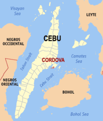
Cordova (Cebu)
| Municipality of Cordoba | ||
| Location of Cordoba in the province of Cebu | ||
|---|---|---|

|
||
| Basic data | ||
| Region : | Central Visayas | |
| Province : | Cebu | |
| Barangays : | 13 | |
| District: | 6. District of Cebu | |
| PSGC : | 072220000 | |
| Income class : | 4. Income bracket | |
| Households : | 9541 May 1, 2000 census
|
|
| Population : | 59,712 August 1, 2015 census
|
|
| Coordinates : | 10 ° 15 ′ N , 123 ° 57 ′ E | |
| Postal code : | 6017 | |
| Website: | cordova.gov.ph | |
| Geographical location in the Philippines | ||
|
|
||
Cordova or Cordoba (Spanish spelling) is a Filipino municipality in the province of Cebu . It has 59,712 inhabitants (August 1, 2015 census).
Mayor of the municipality ("municipality") is Mary Therese P. Sitoy-Cho, who succeeds Atty. Adelino Sitoy.
Cordova is located on an island off the southern tip of the island of Mactan . It is connected to the main island of Mactan and the neighboring municipality of Lapu-Lapu City via three bridges. Cordova is a quiet and somewhat secluded place. The municipality is part of the metropolitan area of Metro Cebu and covers a territory of 740.86 hectares on the main island and approximately 48.76 hectares on small islands that are attached to the municipality. The names of the islands are as follows: Gilutongan, Nalusuan, Shell, Tongo and Lava.
economy
The economy of the city of Cordova is shaped by fishing and trade. 20% percent of households are directly dependent on fishing. In 2007 a total of 1,543 active fishermen were counted. Most of the economic activities are carried out through trade, the rest is shared by tourism and the industrial sector, the latter being limited to the mining and processing of the "Mactan stone", a limestone, the mining is located in the barangays Cogon and Ibabao .
Education System
The municipality of Cordova has 10 public and 2 private primary schools, 1 public and 1 private high school. 75% of the population over the age of 21 have completed elementary and high school education, 23% have completed or started a technical or university education. 2% of those over the age of 21 are listed as illiterate.
Tourism and sightseeing
On the territory of the municipality there are a total of 6 hotels with a total of 118 rooms and 50 bungalows, the number of available beds is not specified. Since tourism has developed into an important branch of the economy in Cordova, the city administration has also promoted the development of eco-tourism in recent years. Since the early 1990s, two marine nature reserves have been designated, which are also open to diving tourism. The two protected areas Gilutongan Marine Sanctuary and Nalusuan Marine Sanctuary cover an area of approximately 26 hectares, but are territorially separated.
The Day-as Boardwalk and Marine Park is located on the main island and offers the best access to the floodplain with its typical mangrove forest, which mainly extends along the western shorelines of the main island and covers about 100 hectares of the municipal area. The Kamampay Public Beach is located in the barangays Buagsong and Catarman and is characterized by its mangrove forests and its large shallow water at low tide.
Near the city is the Olango Wildlife Santuary, which can be reached by boat from Cordova.
Geography, Geology & Climate
Geographically, the municipality of Cordova is located on an island which, together with the island of Mactan , lies almost in the middle of the elongated island of Cebu , separated from Cebu Island by the Cebu Canal and opposite the Island of Bohol by the Strait of Cebu . The two islands Gilutongan and Nalusuan belonging to the city belong geographically to the Olango archipelago. The underground of the city consists almost entirely of shell limestone, which is geologically assigned to the Carcar formation, the formation of which is dated to the border of the Pliocene - Pleistocene , i.e. approx. 3 to 2 million years. The topography of Cordova is given as flat land, the highest point is 10 meters above sea level. According to the current climate classification, the climate in Cordova is assigned to type 3, which means that the seasons are not very pronounced here and are classified as muggy. The months from November to April are relatively dry and the rest of the year is rainy throughout. In Cordova and the neighboring regions there are an average of 10.3 rainy days per month. The maximum is in the months of July (182.1 mm), September (164.2 mm) and October (208.5 mm) with an average of 14 rainy days per month, the minimum is in April with 53.9 mm and an average of 4 rainy days . The total annual precipitation is 1388.7 mm. The highest average daily temperature was in May with 29.2 ° C and the lowest in January with 26.9 ° C. The annual average temperature of Cordova is 28 ° C, 1.5 ° C above the average temperature in the Philippines .
Barangays
Cordova is politically divided into 13 barangays , ten of which are along the coastline, two inland and one barangay on the island of Gilutongan.
- Alegria
- Bangbang
- Buagsong
- Catarman
- Cogon
- Dapitan
- Day-as
- Gabi
- Gilutongan
- Ibabao
- Pilipog
- Poblacion
- San Miguel
swell
- Geographical and socio-economic data socio-economic profile cordova
- Geology: Carcar formation on Sciencelinks Japan
- Climate data 10 ° N 123 ° E: worldclimate.com
Web links
- Official website of Cordova (English)
- Worldclimate.com (English)


