Aloguinsan
| Municipality of Aloguinsan | ||
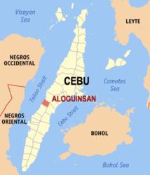
| Location of Aloguinsan in the province of Cebu | ||
|---|---|---|

|
||
| Basic data | ||
| Region : | Central Visayas | |
| Province : | Cebu | |
| Barangays : | 15th | |
| PSGC : | 072204000 | |
| Income class : | 4. Income bracket | |
| Households : | 4821 May 1, 2000 census
|
|
| Population : | 32,100 August 1, 2015 census
|
|
| Population density : | 432.6 inhabitants per km² | |
| Area : | 74.21 km² | |
| Coordinates : | 10 ° 13 ' N , 123 ° 33' E | |
| Postal code : | 6040 | |
| Geographical location in the Philippines | ||
|
|
||
Aloguinsan is a 4th income class Filipino township in the province of Cebu . It has 32,100 inhabitants (August 1, 2015 census).
The community is located on the west coast of the island of Cebu , approx. 73 km southwest of Cebu City and can be reached via the coastal road via Toledo City . Their neighboring communities are Pinamungahan in the north, San Fernando and Carcar City in the east and Barili in the south. To the west of the municipality is the island of Negros, from which it is separated by the Tanon Strait .
Barangays
Aloguinsan is politically divided into 15 barangays :
- Angilan
- Bojo
- sweet
- Esperanza
- Kandingan
- Cantabogon
- Kawasan
- Olango
- Poblacion
- Punay
- Rosario
- Saksak
- Tampa-on
- Toyokon
- Zaragosa
Web links
- Aloguinsan on the website Cebu The Philippine Bestsellers ( Memento from April 13, 2009 in the Internet Archive )
