Danao City
| Danao City | ||
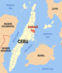
| Location of Danao City in the province of Cebu | ||
|---|---|---|

|
||
| Basic data | ||
| Region : | Central Visayas | |
| Province : | Cebu | |
| Barangays : | 43 | |
| District: | 5. District of Cebu | |
| PSGC : | 072223000 | |
| Income class : | 3rd income bracket | |
| Households : | 19,411 May 1, 2000 census
|
|
| Population : | 136,471 August 1, 2015 census
|
|
| Population density : | 1272 inhabitants per km² | |
| Area : | 107.30 km² | |
| Coordinates : | 10 ° 31 ' N , 124 ° 1' E | |
| Mayor : | Ramonito Durano ( NPC ) | |
| Geographical location in the Philippines | ||
|
|
||
Danao City is a Philippine city ( component city ) of the 2nd income bracket in the province of Cebu . It has 136,471 inhabitants (August 1, 2015 census).
In 2005, Metro Cebu was expanded to include Danao City in the north and San Fernando and Carcar in the south .
Barangays
Danao City is politically divided into 43 barangays .
|
|
|
