Badian (Cebu)
| Municipality of Badian | ||
 |
||
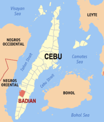
| Location of Badian (Cebu) in the province of Cebu | ||
|---|---|---|

|
||
| Basic data | ||
| Region : | Central Visayas | |
| Province : | Cebu | |
| Barangays : | 29 | |
| District: | 2. District of Cebu | |
| PSGC : | 072207000 | |
| Income class : | 4. Income bracket | |
| Households : | 6230 May 1, 2000 census
|
|
| Population : | 37,912 August 1, 2015 census
|
|
| Coordinates : | 9 ° 52 ' N , 123 ° 24' E | |
| Postal code : | 6031 | |
| Geographical location in the Philippines | ||
|
|
||
Badian is a 4th income class Filipino township in the province of Cebu . According to the census of August 1, 2015, it has 37,912 inhabitants. It is located about 98 km southwest of Cebu City . Their neighboring communities are Moalboal in the north, Alegria in the south and the communities Dalaguete and Argao in the east. In the west the community borders on Tanon Street . Tourist attractions include the Kawasan Falls, Badian Island and Green Island.
Barangays
Badian is politically divided into 29 barangays .
|
|
|
Web links
- Badian on Philippine Bestsellers ( Memento from December 18, 2009 in the Internet Archive )
