San Remigio (Cebu)
| Municipality of San Remigio | ||
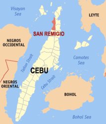
| Location of San Remigio in the province of Cebu | ||
|---|---|---|

|
||
| Basic data | ||
| Region : | Central Visayas | |
| Province : | Cebu | |
| Barangays : | 27 | |
| District: | 4. District of Cebu | |
| PSGC : | 072243000 | |
| Income class : | 3rd income bracket | |
| Households : | 9253 May 1, 2000 census
|
|
| Population : | 57,557 August 1, 2015 census
|
|
| Coordinates : | 11 ° 5 ' N , 123 ° 56' E | |
| Postal code : | 6011 | |
| Mayor : | Mariano B. Martinez | |
| Website: | www.sanremigio.gov.ph | |
| Geographical location in the Philippines | ||
|
|
||
San Remigio is a Filipino municipality in the province of Cebu . It has 57,557 inhabitants (August 1, 2015 census).
The community is located in the northwest of the island of Cebu about 109 km from Cebu City , the community can be reached from there in about three hours by car. From the port in Barangay Hagnaya, ferries leave every day for the island of Bantayan . It is bordered by Hagnaya Bay to the north, Bogo City and Tabogon to the east, Tabuelan to the south and Tanon Strait to the west .
Barangays
San Remigio is politically divided into 27 barangays .
|
|
