Barili
| Municipality of Barili | ||
 |
||
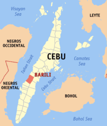
| Location of Barili in the province of Cebu | ||
|---|---|---|

|
||
| Basic data | ||
| Region : | Central Visayas | |
| Province : | Cebu | |
| Barangays : | 42 | |
| District: | 3. District of Cebu | |
| PSGC : | 072210000 | |
| Income class : | 3rd income bracket | |
| Households : | 11,164 May 1, 2000 census
|
|
| Population : | 73,862 August 1, 2015 census
|
|
| Population density : | 630.5 inhabitants per km² | |
| Area : | 117.15 km² | |
| Coordinates : | 10 ° 7 ' N , 123 ° 31' E | |
| Geographical location in the Philippines | ||
|
|
||
Barili is a Filipino municipality in the province of Cebu .
geography
Barili is 61 km southwest of Cebu City . It borders the municipalities of Dumanjug in the south, Aloguinsan in the north, Carcar City and Sibonga in the east. To the west is the Tanon Strait which separates the islands of Cebu and Negros .
Barangays
Barili is politically divided into 42 barangays .
|
|
|
history
The name Barili is derived from balili , the name for an indigenous grass. The municipality was founded in 1632, the parish was established as early as 1614. In 1602, when the Spaniards arrived, a cross was erected under the leadership of Juan Juarado . That cross still exists today.
economy
Barili's main products are rice , corn , bananas and coconuts .
Web links
- elgu.ncc.gov.ph - Barili ( Memento from February 6, 2007 in the Internet Archive )

