Pinamungajan
| Municipality of Pinamungajan | ||
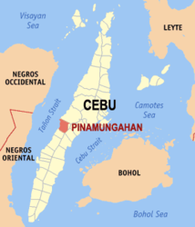
| Location of Pinamungajan in the province of Cebu | ||
|---|---|---|

|
||
| Basic data | ||
| Region : | Central Visayas | |
| Province : | Cebu | |
| Barangays : | 26th | |
| District: | 3. District of Cebu | |
| PSGC : | 072237000 | |
| Income class : | 2nd income bracket | |
| Households : | 9977 May 1, 2000 census
|
|
| Population : | 65,955 August 1, 2015 census
|
|
| Population density : | 562.5 inhabitants per km² | |
| Area : | 117.25 km² | |
| Coordinates : | 10 ° 16 ' N , 123 ° 35' E | |
| Postal code : | 6039 | |
| Mayor : | Geraldine P. Yapha | |
| Geographical location in the Philippines | ||
|
|
||
Pinamungajan (also: Pinamungahan ) is a Filipino municipality in the province of Cebu . It has 65,955 inhabitants (August 1, 2015 census).
The community is located on the west coast of the island of Cebu on the Tanon Strait opposite the island of Negros , about 65 km west of Cebu City . Their neighboring communities are Toledo City in the north, Naga City and San Fernando in the east, and Aloguinsan in the south.
Pinamungajan was founded in 1815 by the Spanish colonial authorities, the name means 'hard-working farm workers' in Cebuano .
Barangays
Pinamungajan is politically divided into 26 barangays .
|
|
Web links
- Pinamungajan on the website of the Philippine Bureau of Statistics
- elgu.ncc.gov.ph - Pinamungahan ( Memento from July 19, 2008 in the Internet Archive )
- Pinamungajan on the website Cebu The Philippines Bestsellers ( Memento from June 20, 2009 in the Internet Archive )
- Pinamungajan on cebuwatch.com
