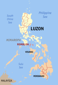
Romblon Province
| Basic data | |
|---|---|
| Region : | MIMAROPA |
| Capital : | Romblon |
| Population : | 292,781 August 1, 2015 census
|
| Population density : | 191 inhabitants per km² |
| Area : | 1,533.45 km² |
| PSGC : | 175900000 |
| Official website: | official website |
| structure | |
| - Highly urbanized cities | |
| - provincial cities | |
| - municipalities | 17th |
| - Barangays | 219 |
| - electoral districts | |

|
|
Coordinates: 12 ° 33 ′ N , 122 ° 17 ′ E Romblon is an island province of the Philippines in the MIMAROPA region. The capital is the homonymous municipality Romblon . According to the previous administrative structure, the province belonged to Southern Tagalog .
geography
The province is located in the Sibuyan Sea about 350 km south of Manila, in the west it borders on the Tablas Strait . It is located south of Marinduque and Quezon Province on Luzon , east of Mindoro , north of Aklan Province on Panay and west of Masbate .
It consists of numerous islands - the largest are Tablas in the west, Sibuyan in the east and the smaller Romblon in between . The highest mountain in the province is the 2,058 meter high Guiting-guiting . The province is the country's leading producer of high-quality marble, which is roughly the same quality as Italian marble.
People and culture
languages
There are three main different languages spoken by Romblon residents: Romblomanon , Asi and Onhan . Depending on the situation, Hiligaynon , Tagalog , Visayan and English are also spoken.
religion
The majority of the residents of Romblon Province are Christians , 75% belong to the Roman Catholic Church and 25% to the Independent Church of the Philippines , the Iglesia ni Cristo , the Church of the Last Seven Days (Adventists) , the Baptists , the Church of Foursquare Gospel in the Philippines and other Christian styles.
origin
Most of Romblon's current residents are descendants of Malay settlers who probably landed on Romblon around AD 1200. From 1582, when the Spanish conquerors reached the Philippines, they administered this province. Some old Spanish forts and churches, which were built from unique coral stones with intricately intertwined inlay work, still bear witness to this today.
economy

The Romblon Province is classified as a third class province. Located in the geographical center of the island world (the archipelago) Romblon connects the greater areas of Luzon , Visayas and Mindanao . Tugdan Airport on the island of Tablas, which used to be served by several flights a week, is to be served by Manila again in 2014. Direct ship connections from Manila and with the ports in Batangas City and Lucena City in southern Luzon strengthen the connection to the industrial region of Calabarzon , making the province an ideal location for both cargo handling and small craft businesses.
Natural resources
Romblon has lush vegetation and many mineral resources. In addition to marble, the islands are rich in granite, nickel, silicon sands and quartz, mercury, zinc, copper, silver, calcium carbonate, sulfides, ores, various clays (including white clay) and magnesium. On Magdiwang and Sibuya, gold washers have also set up shop on some mountain rivers. The fertile soil produces various agricultural products such as coconuts, rice, corn, bananas, root vegetables, fruits, wine and many others. There are abundant fishing grounds off the coast, as the fish trails pass by, coming from the Sulumeer and Visayas Sea and passing the Strait of Tablas, the Romblon Pass and through the Sibuyan Sea.
Political structure
Romblon is divided into 17 parishes:
Colleges
history
The Romblon province was initially called "Lomlon". This meant the hatching of the eggs by a chicken. The name is said to have originated because a Spanish soldier, who is said to have asked the islanders for the name of the island, accidentally pointed in the direction of a chicken that was just brooding. In response, he is said to have received “Nagalumyom”, which was subsequently changed to “Lomlom”, then to “Donblon” and finally to “Romblon” by the Spaniards. So the name is based on a misunderstanding.
The Spanish built the Fuerza de San Andres at the beginning of the 17th century. The Spanish conquerors made Romblon a politico-military district in 1853 and divided the sub-province of Capiz, which became an independent province in 1917. On October 1, 1946, Romblon was converted to a special province with four parishes. These were Tablas, Romblon, Sibuyan and Maghali. On January 1, 1947, the regular provincial status was restored.
The original inhabitants of Romblon were Negritos from Panay and Mangyan tribes of Mindoro Island . Ancient hanging coffins and artifacts from local people have been found in caves on Banton Island. This indicates a well developed ancient civilization and culture.
Shipwrecks
- Mactan , off the island of Maestro de Campo , sank on July 16, 1973 and is considered to be easily accessible for divers
Sources and further information
- Odiongan homepage
- Romblon Travel Guide
- Romblon ... A Journey of Discovery
- Sanrokan Online
- Banton, a Paradise Island
- Romblon, Our Island Home
- Romblon is a heritage town
- Romblonpost


