Calatrava (Romblon)
| Municipality of Calatrava | ||
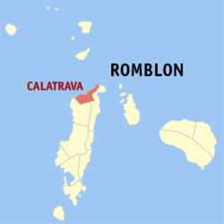
| Location of Calatrava in the Romblon province | ||
|---|---|---|

|
||
| Basic data | ||
| Region : | MIMAROPA | |
| Province : | Romblon | |
| Barangays : | 7th | |
| PSGC : | 175904000 | |
| Income class : | 5th income bracket | |
| Households : |
May 1, 2000 census
|
|
| Population : | 10,275 August 1, 2015 census
|
|
| Population density : | 118.5 inhabitants per km² | |
| Area : | 86.70 km² | |
| Coordinates : | 12 ° 37 ′ N , 122 ° 4 ′ E | |
| Postal code : | 5503 | |
| Geographical location in the Philippines | ||
|
|
||
Calatrava is a Filipino municipality in the province of Romblon and belongs to the administrative region IV-B, Mimaropa. It has 10,275 inhabitants (August 1, 2015 census). It is classified as a fifth income class community in the Philippines and as partially urbanized .
Calatrava is located in the north of the island of Tablas on the coast of the Sibuyan Sea . The topography of the municipality is characterized by flat, undulating terrain. In the south are the municipalities of San Agustin and San Andres .
The Romblon State University's School of Inland Fisheries is located in the community.
Barangays
In 2011 the community consisted of seven barangays :
|
