
Gosen Canal
| Gosen Canal | |
|---|---|
 On the west bank of the Gosen Canal |
|
| Water code | DE : 582892 |
| length | 2.8 km |
| Built | 1923-1936 |
| Expanded | 1993 |
| Beginning | Seddinsee |
| The End | Dämeritzsee |
| Historical precursors | Gosener Graben |
| Outstanding structures | a bridge |
| Responsible WSD | Federal Waterways and Shipping Administration and Berlin Waterways and Shipping Office |
 |
|
The Gosener Canal (GoK) in Berlin is a section of the federal waterway , which is referred to as the Seddinsee and Gosener Canal (WSG) and is legally part of the Spree-Oder waterway. It connects the Seddinsee with the Dämeritzsee and crosses the European bird sanctuary Müggelspree . The canal thus creates a connection between the Spree-Oder waterway and the Rüdersdorfer waters and its industrial sites. The GoK is designated as waterway class III. The Berlin Waterways and Shipping Office is responsible for administration .
The Gosener Graben , which has been closed for an indefinite period of time since 2018, runs parallel to the Gosener Canal to the east and which is otherwise only allowed to be entered by small pleasure craft without a machine drive.
The channel
The total length of the canal between the edges of the lake is 2.8 kilometers (WSG km 2.90 to 5.73). A lock was not necessary in the canal, as there is no significant difference in water level between the lakes. It was built for Plauer-Maß ships , was 2.25 meters deep, had a bottom width of 16 meters and a water level width of 30 meters. In 1993, a one-sided widening of the canal with bank sheet piling and a deepening to 3.00 m was completed.
The Neue Fahlenbergbrücke crosses the canal . It leads the Gosener Landstrasse (L 39) between Gosen-Neu Zittau and Müggelheim across the water. It is dilapidated and should be rebuilt from 2018.
history
As early as 1872 there was a plan to create a shipping canal between the two lakes in the course of the Gosener Graben. An expansion of the waterway in 1891 together with the Oder-Spree Canal could not be realized. In a later plan, the canal route was relocated west of the Gosener Graben in the urban Berlin permanent forest in order to avoid compensation from over 100 property owners when the Gosener Graben was expanded. The first clearing work to prepare the canal construction began in the early 1920s. As a result of the hyperinflation , however, the work was stopped. The first groundbreaking ceremony was not officially carried out until August 1933. At the end of January 1936, traffic was opened and the Gosen Canal was officially named by the Reich Ministry of Transport.
Reasons for building canals
- Shortening the distance between the industrial area on the Rüdersdorfer Waters and the industry around Niederlehme and Königs Wusterhausen by around 18 km
- Increasing traffic safety on the surrounding waterways by relieving them
- Cultivation and drainage measures
- The most important and decisive reason, however, was to bypass the regatta course in Berlin-Grünau for the time of the 1936 Summer Olympics . It is possible that inland waterway operators would have been asked for compensation if the waterway had been closed during the Olympic Games.
Maps and pictures

Entrance from Seddinsee into the Gosen Canal
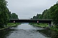
New Fahlenberg Bridge

Lakes and waterways in southeast Berlin, the Gosen Canal is in the middle on the right

Passenger ships in the Gosen Canal August 1976
.JPG)
.JPG)


literature
- Hans-Joachim Uhlemann: Berlin and the Märkische waterways. transpress publishing house for transport, Berlin 1987, ISBN 3-344-00115-9 .
- Western European shipping and port calendar. Binnenschifffahrts-Verlag GmbH. Duisburg-Ruhrort various years. OCLC 48960431
- Sportschifffahrtskarten Binnen 1 Nautical Publication Verlagsgesellschaft, ISBN 3-926376-10-4 .
cards
- Folke Stender: Editing of Sportschifffahrtskarten inland 1. Nautical publication Verlagsgesellschaft, ISBN 3-926376-10-4 .
- W. Ciesla, H. Czesienski, W. Schlomm, K. Senzel, D. Weidner: Shipping maps of the inland waterways of the German Democratic Republic 1: 10,000. Volume 4. Editor: Waterways Authority of the GDR, Berlin 1988, OCLC 830889996 .
See also
Web links
Individual evidence
- ↑ Directory E, serial no. 55 of the Chronicle , Federal Waterways and Shipping Administration
- ↑ History of the Seddinsee and Gosen Canal (WSG)
- ↑ Lengths (in km) of the main shipping lanes (main routes and certain secondary routes) of the federal inland waterways, federal waterway and shipping administration
- ↑ H.-J. Uhlemann, Berlin and the Märkische Wasserstraßen, DSV-Verlag Hamburg 1994
- ^ Reichsverkehrsblatt A 1936 p. 31
Coordinates: 52 ° 24 ′ 35 ″ N , 13 ° 42 ′ 37 ″ E