Great Chagos Bank
| Great Chagos Bank | ||
|---|---|---|
|
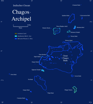
Map of the Chagos Archipelago with the Great Chagos Bank |
||
| Waters | Indian Ocean | |
| archipelago | Chagos Archipelago | |
| Geographical location | 6 ° 10 ′ S , 72 ° 0 ′ E | |
|
|
||
| Number of islands | 8th | |
| Main island | Île Aigle (Eagle Island) |
|
| length | 150 km | |
| width | 100 km | |
| Land area | 4.5 km² | |
| total area | 12,642 km² | |
| Residents | uninhabited | |
The Great Chagos Bank (dt. About Big Chagosbank ) is right in the middle of the Chagos archipelago . It is located about 500 km south of the Maldives and with 12,642 km² is the largest contiguous group of atolls worldwide. The lagoon is an average of 75 meters deep; the greatest depth is 90 meters.
The eight islands are on the edge of the atoll, one in the north (Nelsons Island) and the other on the western edge. The total land area is 4.5 km². The Great Chagos Bank is administratively part of the British Indian Ocean Territory .
The islands in clockwise order starting in the south are:
- Danger Island
-
Eagle Islands ( Îles Aigle )
- Sea Cow Island ( Île Vache Marine )
- Eagle Island ( Île Aigle )
-
Three Brothers ( Trois Frères )
- South Brother Island ( Île du Sud )
- unnamed islet
- Middle Brother Island ( Île du Mileu )
- North Brother Island ( Île du Nord )
- Nelsons Island
Individual evidence
- ^ Reginald Aldworth Daly : The Glacial-Control Theory of Coral Reefs . In: Proceedings of the American Academy of Arts and Sciences . tape 51 , no. 4 , November 1915, Table I: Depths in Lagoons and on Banks, p. 190 , doi : 10.2307 / 20025572 (English).

