Green River (Lillooet River)
| Green River | ||
|
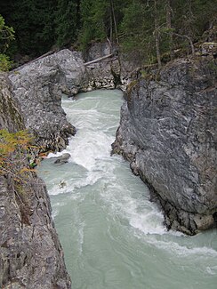
Green River below the Nairn Falls |
||
| Data | ||
| location | British Columbia ( Canada ) | |
| River system | Fraser River | |
| Drain over | Lillooet River → Harrison River → Fraser River → Pacific Ocean | |
| origin |
Green Lake north of Whistler 50 ° 10 ′ 6 ″ N , 122 ° 55 ′ 5 ″ W |
|
| Source height | 633 m | |
| muzzle |
Lillooet River Coordinates: 50 ° 18 '8 " N , 122 ° 43' 16" W 50 ° 18 '8 " N , 122 ° 43' 16" W. |
|
| Mouth height | approx. 200 m | |
| Height difference | approx. 433 m | |
| Bottom slope | approx. 14 ‰ | |
| length | 31 km | |
| Catchment area | approx. 900 km² | |
| Discharge at gauge 08MG003 A Eo : 855 km² Location: 12 km above the mouth |
MQ 1915/1950 Mq 1915/1950 |
48 m³ / s 56.1 l / (s km²) |
| Left tributaries | Soo River , Rutherford Creek | |
The Green River (English for "green river") is a 31 km long right tributary of the Lillooet River in the Canadian province of British Columbia .
River course
The Green River has its origin in the 633 m high Green Lake north of Whistler in the Pacific Ranges , a part of the Coast Mountains . It leaves the lake at its northern end and initially flows mainly in a northerly direction, later in an easterly direction through the mountains. The Soo River and Rutherford Creek flow into the Green River from the left . Then the Green River overcomes Nairn Falls Provincial Park , the Nairn Falls . The Green River eventually reaches the Pemberton Valley and flows 6 km east-southeast of Pemberton into the Lillooet River. The British Columbia Highway 99 (Whistler-Pemberton) follows the course of the Green Lake until after Pemberton.
Hydrology
The Green River drains an area of approximately 900 km². The mean discharge 12 km above the mouth is 48 m³ / s. The highest monthly outflows usually occur between May and August.
Web links
- Green River . In: BC Geographical Names (English)
