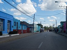
Guáimaro
Coordinates: 21 ° 4 ′ N , 77 ° 21 ′ W
Guáimaro is a municipality and a city in the southern part of the Cuban province of Camagüey . It is located between Camagüey and Victoria de Las Tunas .
The community was formed in 1943 when it split from the city of Camagüey. Guáimaro is divided into the Barrios Elia, Camaniguán, Galbis, Guáimaro, Palo Seco, Tetuán and Pilar.
The city played an important role in the history of Cuba , as the Mambí revolutionary army met here in 1869 to draft a constitution for a Cuba liberated from Spanish rule for the first time.
Demographics
In 2004 the municipality of Guáimaro had 57,087 inhabitants. With a total area of 1847 km², the city has a population density of 30.9 inhabitants / km².
Individual evidence
- ↑ Guije.com: Guáimaro . Retrieved October 5, 2007.
- ↑ Atenas.cu: 2004 Population trends, by Province and Municipality . 2004. Archived from the original on July 14, 2006. Info: The archive link was automatically inserted and not yet checked. Please check the original and archive link according to the instructions and then remove this notice. Retrieved October 5, 2007.
- ^ Statoids: Municipios of Cuba . Retrieved October 5, 2007.

