
Guajataca reservoir
| Guajataca reservoir, Lago Guajataca |
|||||||
|---|---|---|---|---|---|---|---|
 |
|||||||
|
|||||||
|
|||||||
| Coordinates | 18 ° 23 '36 " N , 66 ° 55' 19" W | ||||||
| Data on the structure | |||||||
| Construction time: | Completion in 1928 | ||||||
| Height of the structure crown: | 202.5 m | ||||||
| Crown length: | 316 m | ||||||
| Crown width: | 9.5 m | ||||||
| Data on the reservoir | |||||||
| Altitude (at congestion destination ) | 193 m | ||||||
| Water surface | 3.42 km² | ||||||
| Total storage space : | 42 280 000 m³ | ||||||

The Guajataca Reservoir is a reservoir in Puerto Rico .
description
The reservoir is about 193 meters above sea level in the area of the municipalities of Quebradillas , San Sebastián and Isabela . The Rio Guajataca is the lake's main inflow and only outflow. The reservoir is used to supply drinking water to more than 250,000 people in northwestern Puerto Rico, as a flood protection and for the irrigation of cultivated land.
The dam is 37 meters high, 316 meters long, made of earth and has a clay core. An overflow channel with an overflow threshold at 196.9 meters above sea level serves as a flood relief . The water can drain through a bottom drainage pipe with a diameter of 244 centimeters. A pipe with a diameter of 137 centimeters leads water to a canal that supplies three water treatment plants .
history
The Guajataca Dam was built in the 1920s by the Puerto Rican energy agency Autoridad de Energía Eléctrica . During construction, signs of instability were observed in February 1927, which is why the structure was reinforced by a berm . The reservoir was created in 1928 with the completion of the dam. Its original capacity was 48.46 million m³, due to sedimentation this value was reduced to 42.28 million m³ in 1999. In the years 1954 and 1981–1984 major renovation work was carried out on the dam.
By Hurricane Maria came on 22 September 2017 at damage to the dam. A landslide spilled the outlet of the bottom drainage pipe, causing the water level on the lake to rise rapidly and the water to flow out via the overflow channel. The masses of water washed away soil from the base of the dam and the overflow channel began to break away, a dam breach was feared. The governor of Puerto Rico, Ricardo Rosselló , called on the residents to evacuate the threatened valley. The pipe for the water supply to the treatment plant was also cut.
The American civil protection agency FEMA commissioned the United States Army Corps of Engineers (USACE) with safety and repair work on the dam. In a first phase, the drainage of the bottom outlet was cleared in order to lower the level of the reservoir. In order to minimize further erosion of the earth, US Marines with helicopters from the USS Kearsarge 505 deposited large concrete elements ( Jersey Barriers ) at the base of the damaged flood relief. For the same purpose, the National Guard set up a temporary stilling basin by laying 1,338 large sandbags, each weighing around 1,360 kilograms, as a kind of rubble barrier , also using helicopters .
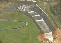
The dam's damaged overflow channel, taken on September 27, 2017

A “ Chinook ” brings a large sandbag to reinforce the overflow channel on October 9, 2017
USACE and National Guard repair work on the dam on October 9, 2017

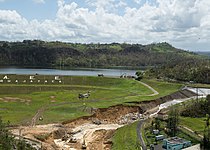
The situation on October 15, 2017. The distribution channel for the water treatment systems can be seen in the foreground

Status in April 2018
.jpg)
.jpg)
.jpg)


Ten pumps were installed by the USACE to keep the lake water level low. In addition, water is pumped into the distribution channel for the water treatment systems in order to restore the drinking water supply. Mobile water treatment systems based on reverse osmosis , installed by the military directly on the lake, enabled residents to collect drinking water in canisters.
After the access roads to the dam had been made passable again for larger vehicles, rubble was delivered from a quarry in order to further strengthen and stabilize the dam. Together with the USACE, the energy authority drew up a plan for the permanent repair of the dam. In October 2019, USACE returned the project to the Puerto Rican government's energy agency.
Web links
supporting documents
- ^ Edward Rivera: Army Corps continue to make significant progress in hurricane recovery operations in Puerto Rico. United States Army , October 31, 2017; Retrieved October 31, 2017 .
- ↑ a b c d e f John MacPherson: DoD provides unique and critical support to Puerto Rico. United States Army, December 1, 2017, accessed December 13, 2017 .
- ↑ a b c Francisco Silva-Tulla, Miguel A. Pando: Geotechnical Extreme Event Site Reconnaissance in Puerto Rico after the Passage of Hurricane Maria. In: International Journal of Geoengineering Case Histories. Volume 5, Issue 4, no year, p. 9 f., Article available online at geocasehistoriesjournal.org.
- ^ NID Detail Report. In: National Inventory of Dams. United States Army Corps of Engineers , September 22, 2017, p. 1 f. , accessed on September 22, 2017 .
- ↑ a b Gregory B. Poindexter: Corps releases details on Guajataca Dam spillway mitigation efforts in Puerto Rico. In: hydroworld.com. October 5, 2017, accessed October 27, 2017 .
- ^ A b Edward Rivera: USACE teams with PRASA to provide water to 100,000 residents, businesses in NW Puerto Rico. United States Department of Defense , November 3, 2017, accessed November 16, 2017 .
- ↑ Luis R. Soler-López: SEDIMENTATION SURVEY RESULTS OF THE PRINCIPAL WATER-SUPPLY RESERVOIRS OF PUERTO RICO. United States Geological Survey , 2005, accessed October 27, 2017 .
- ↑ Aid reaches Puerto Rico after Maria as threat from cracked dam recedes. In: The Guardian . September 24, 2017, accessed October 27, 2017 .
- ↑ Catalina Carrasco: Guajataca Dam repairs, a successful interagency team effort. United States Army, May 13, 2019, accessed January 28, 2020.
- ↑ US Corps of Engineers transfers repaired Guajataca Dam to PR gov't. In: newsismybusiness.com . October 23, 2019, accessed on January 28, 2020.