Hargla
Hargla (German Harjel , Võro Harglõ ) is a village ( Estonian küla ) in the Estonian district of Valga . It belongs to the rural municipality of Valga ( Taheva until 2017 ). Hargla has 228 inhabitants (as of January 1, 2007).
The Hargla area is very rural. The rivers Koiva , Mustjõgi , Peetri and Hargla flow through wide glacial valleys .
In the Middle Ages , the eastern part of the area belonged to the Dorpat diocese , the western part to Urvaste . Probably the first church was built in Hargla in 1667 (destroyed in the Northern War ). With the decree of the Swedish King Charles XI. from April 21, 1694 Urvaste (German Urbs ), Karula ( Karolen ) and Gaujiena ( Adsel ) were united to form the parish of Hargla.
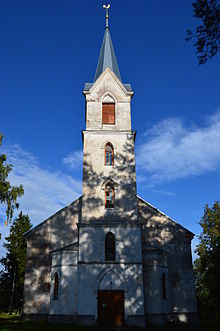
Hargla's landmark today is the neo-Gothic church with its massive tower, built between 1817 and 1821 . The building is typical of the architecture of the representative Livonian country churches of the time. To the east is the cemetery built around 1773 with the grave chapel of the family of the Baltic German Major General von Wassermann (1781).
About 3 km north of Hargla is the 124 m high Essemägi. The German researcher Friedrich Georg Wilhelm Struve carried out his astronomical-geodetic studies there in the 19th century to measure the circumference of the earth. In his writings, Struve praised the beauty of the forests there.
Web links
- Detailed description of the place (Estonian)
- Hargla Church (Estonian)
- History of the parish Hargla (Estonian)
Individual evidence
Coordinates: 57 ° 37 ' N , 26 ° 24' E
