Hühnerberg (Vorkarwendel)
| Chicken Hill | ||
|---|---|---|
|
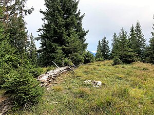
At the Kleiner Hühnerberg |
||
| height | 1625 m | |
| location | Germany ( Bavaria ) | |
| Mountains | Vorkarwendel | |
| Dominance | 0.53 km → Dürnbergjoch | |
| Notch height | 42 m | |
| Coordinates | 47 ° 33 '28 " N , 11 ° 34' 22" E | |
|
|
||
The Hühnerberg is a mountain range in the Upper Bavarian municipality of Lenggries ( Bad Tölz-Wolfratshausen district ).
It is the northernmost part of the arched mountain ridge with an otherwise nameless highest point ( 1625 m ), which extends from this over the short side branch Schürpfeneck, the Dürnbergjoch, the Demeljoch to the Zotenjoch, already on the Austrian side. The northern pre-summit ( 1397 m ) is known as the Kleiner Hühnerberg and once housed the Kirchmair Alm , which has now been abandoned .
The Hühnerberg can be crossed as a mountain hike from the eastern end of the Sylvenstein reservoir as a ridge hike .

