Hüttenstollen
| Hüttenstollen | |||
|---|---|---|---|
| General information about the mine | |||
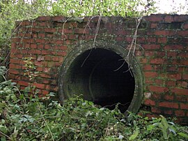
| The mouth hole of the hut tunnel | |||
| Information about the mining company | |||
| Start of operation | before 1696 | ||
| End of operation | 1876 | ||
| Funded raw materials | |||
| Degradation of | |||
| Greatest depth | 50 m | ||
| Geographical location | |||
| Coordinates | 51 ° 37 '6.7 " N , 11 ° 3' 6" E | ||
|
|||
| Location | Strassberg | ||
| local community | Harzgerode | ||
| District ( NUTS3 ) | resin | ||
| country | State of Saxony-Anhalt | ||
| Country | Germany | ||
| District | Strassberg | ||
The Hüttenstollen , also the Straßberger Hüttenstollen , was the central water solution gallery of the Straßberg mining area and thus part of the Lower Harz pond and ditch system in the Harz mining region . The tunnel , with a depth of 50 m, has a length of 750 m. The mine water were to Selke solved . The mouth hole is only a few meters away from the mouth of the rafts .
history
The construction of a deep tunnel began before 1696. The aim was to water and weather solution for Straßberger pits blessing of God , the help of God , God helps certainly and Trust in God (later Glasebach). Georg Christoph von Utterodt , who came from Ilmenau , took over the management of the Straßberg mines in 1701. In the coming years, the tunnel was the Selketal out ahead .
Under Christian Zacharias Koch , the tunnel, which is now known as the Hüttenstollen, was promoted strongly from 1720. By connecting the main tunnels south of Straßberg, the hut tunnels became the central water solution tunnels of the Straßberg pits Getreuer Bergmann (formerly God will certainly help), Glückauf (formerly God's help) and Zum Schwarzen Hirsch . The pits are mutually penetrable .
A final extension took place from 1848 to 1856 to the Kreuz pit . The tunnel was abandoned in 1876.
The Straßberg mines were bought in 1856 by the Straßberg-Haynsche Aktiengesellschaft. The new straightening shaft was connected to the hut tunnel by a 180 m long day tunnel.
Current condition
The tunnel lost its function when the Straßberg pits were closed and some of it was broken . The brick mouth hole of the Hüttenstollen on the Selke can still be seen. Small amounts of mine water still flow into the Selke. Just like the location of the straightening shaft , that of the Hüttenstollen is marked by a sign ( mining fir ). The one of the hut tunnel is, however, a few meters away as the crow flies, in a freely accessible place.
swell
- Wilfried Ließmann: Historical mining in the Harz. 3rd edition, Springer, Berlin 1997, ISBN 978-3-540-31327-4
- The Lower Harz pond and ditch system
- Straßberg / Harz - Mining Firs - Strassberg
- Karl-Heinz Krause, development and current function of systems of historical mining water management in the Lower Harz; in: Wilfried Strenz - Working Group on Historical Geography of the Geographical Society of the GDR, historical-geographical research in the GDR excerpt

