
Haarberg (Aachen)
| Haarberg | ||
|---|---|---|
.jpg) View of the Haarberg |
||
| height | 239.3 m above sea level NHN | |
| location | Aachen , North Rhine-Westphalia , Germany | |
| Coordinates | 50 ° 47 '58 " N , 6 ° 8' 22" E | |
|
||

The hair Mountain is 239.3 meters high, the highest elevation in Aachen municipality hair and belongs to the recreation area of hair and Verlautenheide . At the highest point, a large cross visible from afar is erected, the Haaren Cross . In 1969 a chapel was built not far from the cross according to the plans of the Haaren architect Paul Stollmann, the Catholic Peace Chapel . As part of the "Haarberg Ecology Project", the landscape around the Haarberg was carefully redesigned from 2004 to 2009. Path connections were expanded and orchards and additional biotope areas were created.
geology
The Haarberg lies on the northeastern edge of the Aachen valley basin and belongs geologically to the so-called Verlautenheidener Horst and thus to the northernmost landscape that was formed by layers from the ancient times ( Devonian layers).
history
When American troops advanced from Stolberg and Eilendorf to Haaren in October 1944, the hill in front of Aachen was on the foremost US battle line and played a strategically important role. The Haarberg or "Crucifix Hill", as it was called by the Americans, was correspondingly hard-fought. He changed hands nine times. Eight days after taking the Haarberg, the siege ring around Aachen was closed.
Haarener Cross
In 1891 the first summit cross was erected on the Haarberg. It was 14 m high, made of bricks and plastered in red. The actual cross consisted of two crossing bars that pointed in the four cardinal directions. In the lower part of the complex, biblical scenes were depicted in four niches. The cross was a foundation of the Haaren carpenter and building contractor Johann Georg Gilliam and planned and executed according to his specifications by the Aachen architect Heinrich van Kann . The structure was destroyed in October 1944 - whether it was when the mountain was stormed by artillery fire or whether it was blown up is not clear.
As early as 1947, a new, simple wooden cross was erected on the Haarberg at the suggestion of the pastor Engelbert Willms. This only lasted a few years and was replaced in 1954 by a cross made of impregnated spruce poles. In 1971 the wooden cross was torn down. The then still independent municipality of Haaren had a 15 m high metal cross with an 8 m wide cross beam built according to the plans of the architect Paul Stollmann, which has since stood on a round viewing platform made of concrete.
In memory of the old Haarener Cross, a 1:10 scale replica was made by Franz Josef Heuser and Wilfried Koerens in 2015, which was set up in Akazienstrasse in Aachen-Haaren. In the upper niches there are scenes from the life and suffering of Christ: birth, crucifixion, resurrection and ascension. The lower niches show the four Haaren parish patrons St. Germanus, St. Hubert, St. Elisabeth and St. Martin.
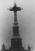
The first Haaren Cross from 1891
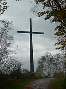
New summit cross built in 1971
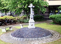
Replica Haarener Cross

Peace Chapel on the Haarberg


Web links
- Battle of Crucifix Hill on Wikipedia
Individual evidence
- ^ Haarberg - Topographical Map 1: 2000. In: TIM-online (Topographical Information Management). District government of Cologne , accessed on April 15, 2016 .
- ^ Hans Breddin: Geologische Mitteilungen , Volume 11, 1970
- ↑ Article fight for the "Crucifix Hill" in Aachener Volkszeitung (AVZ, today the Aachener Zeitung) of 23 August 1984
- ^ Haaren vor den Stadt Aachen , volume 2, publication by the Heimatverein Haaren / Verlautenheide, 1987