
Alexandria Port

The port of Alexandria (Arabic ميناء الإسكندرية - al-Mīnâ al-Iskandariyya) is the largest Egyptian seaport in terms of handling . It has existed since 1900 BC. Chr.
The city of Alexandria is located on the western edge of the Nile Delta between the Mediterranean Sea and the lagoon-like brackish lake Mareotis (بحيرة مريوط - Buḥarat Mariyyūṭ).
Geography and Operation

The port is located on both sides of the Rās at-Tīn (رأس التين) peninsula, which arose from the ancient island of Pharos .
The east port (الميناء الشرقي - al-Mīnâ aš-Šarqiyya) is a boat harbor.
The actual seaport is the Westhafen (الميناء غَرْبِيّ - al-Minâ al-Ğarbiyya). The inner part of the al-Medina district is separated from the outer by a pier, the outer from the open sea by the western headland of the at-Tin peninsula, where a naval base is located, and a newer pier. On the headland stands the tallest of the lighthouses in operation in Alexandria today, at 52 m less than half the height of the ancient one and, erected in 1848, is no longer new.
From 1980 to 1986 the industrial port of El-Dekheila (ميناء الدخيلة - Mīnâ ad-Duhkayla) was built a few kilometers west of the western harbor.
60% of Egypt's foreign trade passes through the ports of Alexandria. The port of Alexandria is also very important for tourism as it is called by many cruise ships. The ports are operated by the Alexandria Port Authority .
history

Sediment examinations from the eastern port suggest that today's al-Iskandriyya was a populated port area from around 2700 to 2200 and from 1000 to 800 BC. Before the conquest of Egypt by Alexander the Great , the country's most important port city was Thonis , which the Greeks called Herakleion , sunk in the Bay of Abukir (خليج أبو قير - Khalīg Abū Qīr) .
Under the reign of Alexander, who may never have been to the place named after him, the port and city began to flourish. With the construction of the seven stadium (hence the name) long dam Heptastadion (Ὲπταστάδιον) to the island of Pharos, two artificial bays were created, the Eunostòs Limên (Eὐνοστòς Λιµήν, "Good-Homecoming-Harbor", later Latin : PORTVS EUSTONVS ) in the west and the Great Harbor (Μέγας Λιµήν, Mégas Limên, later Latin : PORTVS MAGNVS ) in the east.
The bay of the Great Harbor was bordered on the seaward side by sandbanks and reefs. The access has become easier since the Pharos lighthouse stood on a reef between the two main passages and jetties were built on some reefs. The tower was therefore not only important for navigating from a distance, but also for entering the port. Protected harbor basins were created within the bay by moles and artificial islands. A royal palace stood on one of the islands. The Great Harbor was in the middle of the urban development of ancient Alexandria.
Because of a series of sandbanks, entering and leaving the port of Eunostos required a certain degree of caution. Only the southeast corner of the bay bordered the walled city. Here the Alexandria Canal flows into the “Kibotós” (κ κιβοτός, “the box”), a small walled harbor basin.
In addition to the sea ports, ancient Alexandria had two inland ports south of the city, one on the said freshwater canal and one on Lake Mareotis .
After the Pharos Tower had lost its function as a lighthouse in the 14th century, it still marks the entrance to the Great Harbor, as does the Kait Bay Fort (قايت باي - Qāyīt Bāy) , built in its place in 1480 .
Between the ancient names “Eunostus” and “Great” port and today's “West” and “East” ports, the west port was designated as the “old” port and the east port as the “new” port on European maps may indicate interim shifts in use.
See also
Web links
- Alexandria Port Authority (Engl.)
- Dominion Shipping Agences: Alexandria port , detailed information on the commercial port (Engl.)
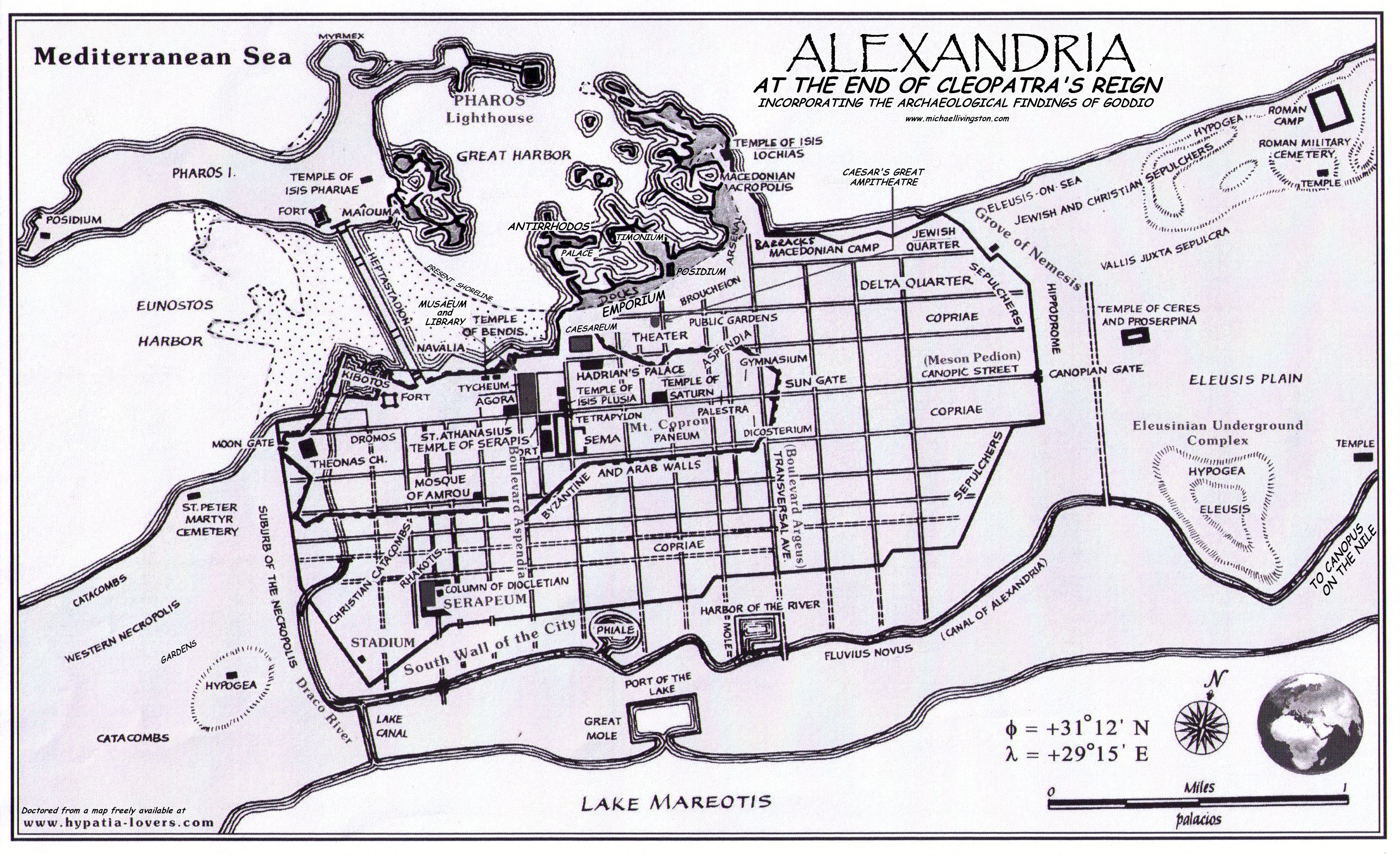
- Alexandria towards the end of Cleopatra's reign, map revised based on Goddio's explorations.
Individual evidence
- ↑ Google search "لميناء غَرْبِيّ" → www.apa.gov.eg/ (هيئة ميناء الإسكندرية = Port of Alexandria): "(الميناء الشرقي) و" (الميناي) و "(الميناya" Minī aschâ. الغâ al-Ğarbiyya »=" Eastern port and western port "
- ^ Lighthouses of Egypt: Mediterranean Sea
- ↑ Alexandria Port Authority: Data on the port of Al-Dukhayla
- ↑ www.pan-marine.net: El-Dekheila port ( Memento of the original from January 3, 2016 in the Internet Archive ) Info: The archive link was inserted automatically and has not yet been checked. Please check the original and archive link according to the instructions and then remove this notice.
- ↑ Alexandria Port Authority (Engl.) Accessed May 7, 2012.
- ↑ Stern - Wissen: Alexandria existed before Alexander
- ^ Pollutant lead reveals the pre-Hellenistic occupation and ancient growth of Alexandria, Egypt. In: Geophysical Research Letters. 33, 2006, doi : 10.1029 / 2006GL025824 (abstract of a scientific article on which the Stern article is obviously based)
- ^ Franck Goddio: Herakleion
- ^ Franck Goddio: Alexandria
Coordinates: 31 ° 12 ′ 16.5 ″ N , 29 ° 52 ′ 48.2 ″ E