
Houston Harbor
| Houston Harbor | |||
|---|---|---|---|
| Data | |||
| UN / LOCODE | USHOU | ||
| operator | Port of Houston Authority | ||
| opening | 1914 | ||
| Port type | Deep water port | ||
| Goods handled | 32.5 million t (2015) | ||
| website | www.portofhouston.com | ||
| Geographic information | |||
| place | Houston | ||
| State | Texas | ||
| Country | United States | ||
| Coordinates | 29 ° 36 '40 " N , 95 ° 1' 18" W | ||
|
|||

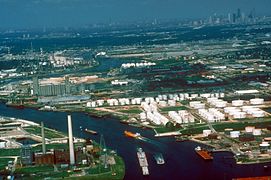
The Port of Houston in Houston , Texas is the second largest seaport in the United States . It stretches 40 km along the Houston Ship Channel . The port entrance on Galveston Bay is spanned by the Fred Hartman Bridge .
history
The modern port of Houston was laid further inland due to the higher hurricane security and opened in 1914 after the completion of the Houston Ship Channel . It quickly developed into an important oil port and refinery location. By 1925 the shipping canal was dredged to a depth of 9 m. In 1942, ARMCO built a steelworks here, followed by aluminum smelters and chemical plants. By 1950/1953 two tunnels were dug to replace the previous ferry traffic.
In 1956, the pioneer Malcom McLean began container shipping on the Houston-New York route. In 1969 the liner service with Europe began. With the opening of the Barbours Cut container terminal in Morgan's Point in 1977, Houston became the largest container port on the Gulf of Mexico. After the capacity could not be increased any further, another terminal ( Bayport , ) was built by 2007 . For the opening of the expanded Panama Canal in 2016, the port will be dredged to a depth of 13.7 m (45 feet ).
![]()

Former ARMCO steel mill (1972)

Barbours Cut container terminal
Houston Ship Channel (1972)
Houston Ship Channel at Galena Park

Houston Ship Channel with DuPont chemical plant in the background


location
The port facilities span the administrative areas of Houston and Harris Counties .
Infrastructure
The port is connected to the road network via several highways. The Port Terminal Railroad Association operates the more than 200 km long port railway. It is connected to the network of the Union Pacific and the BNSF .
Individual evidence
- ↑ 35.75 million short tons ( Port of Houston Authority Total Tonnage ( page no longer available , search in web archives ) Info: The link was automatically marked as defective. Please check the link according to the instructions and then remove this notice. )
- ^ Tonnage of Top 50 US Water Ports, Ranked by Total Tons
- ↑ Trade Statistics ( Memento of the original from June 24, 2016 in the Internet Archive ) Info: The archive link was inserted automatically and has not yet been checked. Please check the original and archive link according to the instructions and then remove this notice.
- ^ A b What a Deep-water Channel to Houston Created
- ↑ Bayport Terminal ( Memento of the original from June 24, 2016 in the Internet Archive ) Info: The archive link was inserted automatically and has not yet been checked. Please check the original and archive link according to the instructions and then remove this notice.
- ↑ The Port of Houston Authority's Future is Here ( Memento of the original from June 24, 2016 in the Internet Archive ) Info: The archive link was inserted automatically and has not yet been checked. Please check the original and archive link according to the instructions and then remove this notice. , September 29, 2015
- ↑ Map of the port ( page no longer available , search in web archives ) Info: The link was automatically marked as defective. Please check the link according to the instructions and then remove this notice.
- ↑ PTRA Rail Network Map