
Hanskalbsand
| Hanskalbsand | ||
|---|---|---|
 |
||
| Waters | Lower Elbe | |
| Geographical location | 53 ° 34 ′ N , 9 ° 40 ′ E | |
|
||
| Residents | uninhabited | |
 |
||


The Hanskalbsand is an uninhabited island in the Lower Elbe between Schulau and Neuenschleuse. The Hanskalbsand belongs to Lower Saxony and borders the Neßsand nature reserve in the east .
The Hanskalbsand is - like the entire Lower Elbe - registered as a fauna and flora habitat and therefore enjoyed almost the same protection in accordance with Section 34 of the Federal Nature Conservation Act until December 31, 2018. In January 2019, the island is part of the " Elbe and Islands " nature reserve .
Landing and entering has not been permitted since 2019. There are exceptions for canoeists on the northern beach section.
The interior of the island is practically inaccessible due to dense vegetation, there are only a few paths. There are only a few beaches on the north side, the width of which depends on the current water level of the Elbe, given a tidal range of three meters.
development
Until around 1959, the Hanskalbsand had remained largely unchanged in terms of size (around 700 meters in length) and location for centuries. It formed the western end of the marshland islands and shallows, which are grouped under the name Schweinesand and which stretched to Blankenese .
The first washings took place in the early 1960s. When the Elbe was deepened in 1970, the Hanskalbsand from the excavation was enlarged to a length of almost two kilometers and washed up to a height of about 3.50 m above sea level. Its western tip, exposed to the flood current, was widened and fortified by reinforcing a rock fill that had been in place since 1924.
It was connected to the Neßsand and Schweinesand upstream of the Elbe via a 3.3 kilometer long and 50–180 meter wide flushing dam . The resulting island was thus given the function of a tail unit .
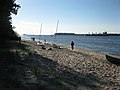
View from Hanskalbsand down the Elbe to the west

See also
Individual evidence
- ↑ Description at bfn.de ( Memento of the original from March 4, 2016 in the Internet Archive ) Info: The archive link was inserted automatically and has not yet been checked. Please check the original and archive link according to the instructions and then remove this notice. , accessed February 28, 2013
- ↑ Landkreis Stade: Ordinance on the nature reserve "Elbe and islands". January 4, 2019, accessed February 15, 2020 .
- ↑ Water sports enthusiasts are affected by the "Elbe and Islands" ordinance / discussions are ongoing: District: "We want to get everyone on board". Accessed February 16, 2020 .
- ↑ Archive link ( Memento of the original dated June 30, 2010 in the Internet Archive ) Info: The archive link was inserted automatically and has not yet been checked. Please check the original and archive link according to the instructions and then remove this notice.
- ↑ Official nautical chart No. 250 of the Reichsmarineamt (all versions) up to nautical chart No. 249 of the DHI as of 1959, VIII
- ^ Nautical chart No. 48 of the DHI from 1962
- ^ Nautical chart of the Reichsmarineamt No. 249 from 1924
- ↑ Official nautical chart No. 48 of the DHI in the versions since 1971