
Neßsand
|
Nature reserve Neßsand (Lower Saxony)
|
||
 Protected nature on pork and wet sand |
||
| location | Elbe island in the Lower Saxony district of Stade , in the Schleswig-Holstein district of Pinneberg and the Hanseatic city of Hamburg . | |
| surface | 145.0 ha | |
| Identifier | NSG LÜ 049 | |
| WDPA ID | 164778 | |
| FFH area | 145.0 ha | |
| Geographical location | 53 ° 33 ' N , 9 ° 45' E | |
|
||
| Sea level | from 0 m to 2 m | |
| Setup date | 17th July 1952 | |
| administration | NLWKN | |

Neßsand is under nature conservation standing Inland Island in the Lower Elbe . This is where the borders of the federal states of Hamburg , Lower Saxony and Schleswig-Holstein meet .
history
During the Second World War, the marshy headland Neßhaken before Finkenwerder was removed, fortified and straightened in order to build the Hamburg aircraft construction plant. The mouth of the Old Süderelbe , the Mühlenberger Loch , which was still adjacent at the time , was dredged as a landing area for seaplanes.
The excavation was deposited down the Elbe, past the pig sand , opposite Wittenbergen . The new island of Neßsand was created right next to the pig sand. Both islands were each around 900 meters long.
The new island probably got its name from the fact that its material - sand - comes from the headland of Finkenwerder known as Neß . The landfill was literally "Neßsand". The product name evidently became a geographical name.
The area has been reforested. The vegetation developed into a partly impenetrable thicket. Even large, hard-to-reach ponds were created, but some of them silted up again.
As part of the deepening of the Elbe from 1965 to 1970, the remaining four-kilometer-long water surface between Hanskalbsand and Neßsand was washed up together with pork sand, so that Hanskalbsand and Neßsand together with pork sand were combined to form a 7.5-kilometer island. Their names were retained, but only referred to regions of the - otherwise nameless - island.
The island is the center of the 170 hectare nature reserve Neßsand, which has existed since 1952 , to which mud flats and the connected island of Schweinesand also belong. In the west it extends to the earlier passage, which today is only recognizable through the rock fillings.
The nature reserve managed by Hamburg is temporarily inhabited and guarded by an island and nature conservation warden, usually in the summer months.
Since 1998, it is, along with the conservation area Mühlenberger hole Natura 2000 site . The part of the nature reserve in Lower Saxony was added to the newly designated " Elbe and Islands " nature reserve in December 2018 .
Entering the area is forbidden, landing and entering is only allowed in the northwestern section of the Schweinesander beach and in the narrow western area.
photos
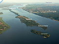
Neßsand and neighboring islands (view downstream to the west)

Map of Neßsand

Radar station on Neßsand


See also
Web links
- Neßsand at the Lower Saxony State Office for Water Management, Coastal Protection and Nature Conservation
- Ordinance on the nature reserve Mühlenberger Loch / Neßsand. (No longer available online.) In: Justizportal Hamburg. Hamburg District Court, October 18, 2005, formerly the original ; accessed on August 2, 2017 . ( Page no longer available , search in web archives )
- Landing sketch Neßsand (PDF file; 1.2 MB)
- Neßsand at the nature conservation association GÖP
- Mühlenberger Loch / Neßsand at the authority for urban development and the environment, City of Hamburg
- Neßsand at the BUND. (No longer available online.) Formerly in the original ; accessed on August 2, 2017 . ( Page no longer available , search in web archives )
- Neßsand at NABU. (No longer available online.) Formerly in the original ; accessed on August 2, 2017 . ( Page no longer available , search in web archives )
Individual evidence
- ↑ Ordinance on the “Neßsand” nature reserve (Lower Elbe), in the Schleswig-Holstein part of the Pinneberg district. In: GVOBl. 1952 149. Landesportal Schleswig-Holstein, August 30, 1952, accessed on March 14, 2020 .
- ↑ Official Nautical charts of the High Command of the Kriegsmarine No. 250 in the versions of the 1940s and 1950s. On the map of the DHI from 1951, 18th VIII, it was only a nameless shoal, only in the map from 1954th V Neßsand appears as a name and island.
- ↑ Official nautical chart of the DHI No. 48 from 1969 and following
- ↑ "Neßsand" nature reserve in the database of the Lower Saxony State Office for Water Management, Coastal and Nature Conservation (NLWKN)
Allermöher meadows | Meadow landscape of the Upper Tide Elbe | Boberger Niederung | Borghorster Elbe landscape | Diekbek | The riding | Duvenstedter Brook | Duve wiping | Eppendorfer Moor | Finkenwerder Süderelbe | Fischbeker Heide | Flottbektal | Hainesch / Iland | Haylock | Holzhafen | Höltigbaum | Hummelsbüttel Moors | Lapwing Brace | Kirchwerder Meadows | Bog belt | Mühlenberger Loch / Neßsand | Neuländer Moorwiesen | Raakmoor | Rhee | Rodenbeker Quellental | Rothsteinsmoor | Schnaakenmoor | Sand of silence | Stacking fields moor | Stellmoorer Tunneltal | Volksdorfer Teichwiesen | Westerweiden | Wittenbergen | Wittmoor | Wohldorfer Forest | Zollenspieker


Buttermoor / Butterbargsmoor | Elbe island Pagensand | Eschschallen in the Seestermüher foreland | Haseldorfer Inner Elbe with Elbe foreland | Heligoland rock base | Holmmoor | Liether Kalkgrube | Lummenfelsen on the island of Helgoland | Neßsand | Tävsmoor / Haselauer Moor