Pig sand
The Elbe islands opposite Hamburg-Blankenese are traditionally referred to as pork sand (or pork sand) .
Today, the pig sand is only a small, reed-covered headland on the east side of the much larger Neßsand opposite Blankenese.
The pig sand is part of the Neßsand nature reserve . Entry is prohibited.
history
In front of Hamburg , the 400-meter-wide Elbe fans out into a widespread inland delta , in which the port of Hamburg extends today. Norder- and Süderelbe enterprise separate ways and streamed originally Mühlenberger hole before Blankenese together again (now on the Köhlbrand amounting Hamburg-Altona ). At the height of Blankenese, the reunited river reaches a width of up to 2.5 kilometers and is subject to the tides , so that it is shallow and interspersed with numerous shallows, mud flats and islands.
For around 200 years the different islands, mud flats, sandbanks and marshes have been referred to as "pig sand " (more rarely "pig sand "). Before that, they appeared on cards as "Blankeneser Sand".
The "Kleine Schweinsand" in front of Blankenese and a sandbank with this name in front of Schulau were about nine kilometers apart. The ebb and flow of the tide cause constant changes; both no longer exist today.
A small island across from the waterworks on Kösterberg in Blankenese ( 53 ° 33 ′ N , 9 ° 46 ′ E ) has been known as Schweinsand since the 19th century. The Hanskalbsand at the western end of this region has also been marked on the maps for centuries.
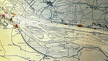
Due to a plan that has been recorded in the nautical charts since 1914, the Hanskalbsand and Schweinsand have been enclosed by a dam since the 1920s. This elongated rock fill falls dry at low water levels, but otherwise remains passable. In between there were shoals and mud flats, and halfway there was also a narrow navigable passage diagonal to the Elbe. Even if the main dam is only visible in parts, it still represents the outer frame of the various islands.
During the Second World War , the Mühlenberger Loch was dredged for the purpose of aircraft construction in Hamburg and the excavated material was deposited down the Elbe, past the Schweinsand island, opposite Wittenbergen . This is how the new island of Neßsand was created next to the pig sand , only separated by a creek .
At the same time, the "Kleine Schweinsand" and the neighboring island of Böhaken to the southwest disappeared . This approximately 500 m × 250 m large march had been on the southern bank of the Elbe at 53 ° 32 ' N , 9 ° 48' E across from Cranz for centuries and until the early 1940s . At the end of the 1940s, Böhaken was only recognizable as a shoal on the nautical charts, and during the 1950s Böhaken disappeared completely.
As part of the deepening of the Elbe from 1965 to 1970, the remaining four kilometers between Hanskalbsand and Neßsand along with pig sand were washed up and connected with a 50 to 180 meter wide land bridge, so that the three earlier islands were united to form a 7.5 kilometer long, dumbbell-shaped island . Their names were retained, but since then only refer to regions of the - as a whole, nameless - island. Since then, locals only speak of "Meier's sand" or simply of "sand".
present
The Süderelbe has been sealed off since 1962. The concreted fairway with a target depth of 14 m takes up almost 400 meters on the north side of the Elbe. The much larger, southern part of the Elbe continues to follow the influence of tides, wind and hydraulic engineering.
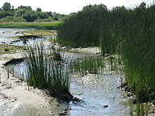
In contrast to the neighboring Neßsand, the pig sand is not forested, but overgrown with reeds as high as a man and impenetrable ( Pompesel ). The southern part silted up, so that the pig sand currently only exists as a flat and narrow extension of the Neßsand.
Immediately upstream ( 53 ° 33 ′ N , 9 ° 47 ′ E ), roughly as far as the previous dam, a new island was created around 1980, a sand dune with low vegetation. Their beaches can be entered. It doesn't have a name.
A little south of the former "Little Pig Sand" ( 53 ° 33 ' N , 9 ° 48' E ) there is now a massive sandbank known as Sherry Island ( 53 ° 33 ' N , 9 ° 48' E ), which at low Wasserstand 2006 was the scene of a demonstration organized by the local sailing clubs against further silting up of the Mühlenberger Loch.
Web links
- Sketch of Neß and pig sand (PDF; 1.19 MB)
- Ordinance on the Neßsand nature reserve
- Neßsand on hamburg.de
- Pigs Sand - An island full of secrets (1997) in theInternet Movie Database(English)
Individual evidence
- ^ Nautical charts of the Reichsmarineamt Berlin from 1905 to 1929
- ↑ Drawn in on map no.250 of the High Command of the Kriegsmarine in 1943, sandbank as of 1951, no longer recognizable on map no.250 of the DHI in the versions from 1951 to 1954
- ↑ Official nautical chart of the DHI No. 48 from 1969 and following
- ↑ Official nautical charts of the DHI No. 48 from 1982 and later
- ↑ Official Nautical chart no.250 from 1905
- ↑ This name is also the Wassergütestelle same used
- ↑ Blankeneser Segel-Club and Mühlenberger Segel-Club , cf. Demonstration call ( page no longer available , search in web archives ) Info: The link was automatically marked as defective. Please check the link according to the instructions and then remove this notice. and The fight of the sailors against the sand . In: The world
Coordinates: 53 ° 33 ' N , 9 ° 46' E


