
Wittenbergen nature reserve
|
Wittenbergen nature reserve
|
||
 Sand path in the heather area of the nature reserve |
||
| location | Hamburg , Germany | |
| surface | 67 ha | |
| WDPA ID | 166342 | |
| Geographical location | 53 ° 34 ' N , 9 ° 45' E | |
|
||
| Setup date | 1986/2010 | |
| administration | BSU | |

The Wittenbergen nature reserve , formerly the Wittenbergener Heide / Elbwiesen nature reserve , is located on the Lower Elbe in the Rissen district of Hamburg .
Until May 31, 2010, the nature reserve Wittenbergener Heide / Elbwiesen consisted of two parts, the Wittenbergener Heide and the Elbwiesen, which together covered 39 hectares . It was by the Regulation on the nature reserve Wittenbergener Heide / Elbwiesen of 24 June 1986 to the nature reserve declared.
On June 1, 2010, the authority for urban development and the environment in Hamburg announced the expansion of the area to include biotopes and renaturable areas in the vicinity of the existing NSG to 67 hectares. In the course of the expansion, the name was changed to the Wittenbergen nature reserve .
The entire site is looked after by NABU .
Wittenbergen Heath
The Wittenbergener Heide stretches from the Tinsdaler Kirchenweg in the north to the Elbe in the south and from Tinsdal in the west to near the Wittenbergener Weg in the east. The area is in the upper part, the highest Hamburger Elbhang from heathland , Kratteichen and an inland dune , a remnant of a 10,000-year-old crescent dunes train that of Wittenbergen about Schnaakenmoor to Elmshorn handed, and runs the Geesthang down to the Wittenbergener lighthouse on the Elbe.
Coordinates: 53 ° 34 ′ 4.1 ″ N , 9 ° 45 ′ 2.1 ″ E
Wittenbergen Elbe meadows
The associated Elbe meadows, which are regularly flooded by the tide, are located a little further up the Elbe near the Falkensteiner Ufer , Hamburg's last natural beach. With their variety of plants, consisting of comfrey , ore angelica , red butterbur , marsh marigold , water swaths and the rare checkerboard flower , they are now among the most nutrient-rich areas in northern Germany , although the checkerboard flower has probably only settled there over the years.
Coordinates: 53 ° 33 ′ 52.5 " N , 9 ° 45 ′ 35.1" E

Blooming Wittenbergen Heath at the end of August

Kratteiche in NSG
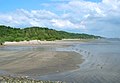
The Falkensteiner Ufer


See also
Individual evidence
- ↑ BUND - Wittenbergener Heide and Elbwiesen
- ↑ Map of Hamburg's nature reserves
- ↑ Ordinance on the Wittenbergener Heide / Elbwiesen nature reserve of June 24, 1986 ( page no longer available , search in web archives ) Info: The link was automatically marked as defective. Please check the link according to the instructions and then remove this notice.
- ↑ Ordinance on the Wittenbergen nature reserve of June 1, 2010 ; Retrieved October 6, 2010
- ↑ The area of the Wittenbergen nature reserve is doubled ; Retrieved June 25, 2010
- ↑ BUND Hamburg welcomes the expansion of the Wittenbergen protected area ( memento of the original from June 9, 2010 in the Internet Archive ) Info: The archive link has been inserted automatically and has not yet been checked. Please check the original and archive link according to the instructions and then remove this notice. ; Retrieved June 25, 2010
- ↑ List of Hamburg's nature reserves (PDF; 93 kB); Retrieved October 6, 2010
- ↑ NABU - The Wittenbergener Heide with the Elbfeuchtwiesen ( Memento of the original from May 29, 2008 in the Internet Archive ) Info: The archive link was inserted automatically and has not yet been checked. Please check the original and archive link according to the instructions and then remove this notice.
- ↑ hamburg.de - Wittenbergener Heide / Elbwiesen nature reserve
Web links
- Wittenbergen nature reserve on hamburg.de
- Ordinance on the Wittenbergen nature reserve from June 1, 2010 with a map of the Wittenbergen nature reserve
- Nature reserve Wittenbergen with picture gallery at kontrastkammer.de
Allermöher meadows | Meadow landscape of the Upper Tide Elbe | Boberger Niederung | Borghorster Elbe landscape | Diekbek | The riding | Duvenstedter Brook | Duve wiping | Eppendorfer Moor | Finkenwerder Süderelbe | Fischbeker Heide | Flottbektal | Hainesch / Iland | Haylock | Holzhafen | Höltigbaum | Hummelsbüttel Moors | Lapwing Brace | Kirchwerder Meadows | Bog belt | Mühlenberger Loch / Neßsand | Neuländer Moorwiesen | Raakmoor | Rhee | Rodenbeker Quellental | Rothsteinsmoor | Schnaakenmoor | Sand of silence | Stacking fields moor | Stellmoorer Tunneltal | Volksdorfer Teichwiesen | Westerweiden | Wittenbergen | Wittmoor | Wohldorfer Forest | Zollenspieker

Altona balcony | Altonaer Volkspark | Antonipark | August-Lütgens-Park | Baurs Park | Bertha-von-Suttner-Park | Bismarckstein | Bonnepark | Bornpark | Thunder Park | Emil-Wendt-Park | Fishing park | Goßlers Park | Hans-Christian-Andersen-Park | Harkenseepark | Heine Park | Hessepark | Hindenburgpark | Deer Park | Jenischpark | Klövensteen | Lise Meitner Park | Loki Schmidt Garden (Hamburg Botanical Garden) | Lunapark | Luther Park | Luuspark | Osdorfer Feldmark | Republic Square | Rathenaupark | Reemtsmapark | Roman garden | Rose garden | Schinckels Park | Schleepark | Schöns Park | Schröder's Elbpark | Sternschanzenpark | Sven-Simon-Park | Tinsdaler Heide | Falkenstein Forest Park | Marienhöhe Forest Park | Walter Möller Park | Westerpark | Wesselhoeftpark | Wohlers Park