
Stellmoorer Tunneltal nature reserve
|
Stellmoorer Tunneltal nature reserve
|
||
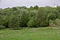
 View over the Stellmoor tunnel valley |
||
| location | Hamburg , Germany | |
| surface | 217 ha | |
| WDPA ID | 82637 | |
| Geographical location | 53 ° 38 ' N , 10 ° 11' E | |
|
||
| Setup date | 1978 | |
| administration | BSU | |


The Stellmoorer Tunneltal nature reserve is located in the Hamburg district of Rahlstedt near the Höltigbaum and Ahrensburger Tunneltal nature reserves on the border with Schleswig-Holstein . It is a European protected area according to the Fauna-Flora-Habitat Directive .
development
The approximately 217 hectare nature reserve was granted protection status on March 28, 1978, making it one of the older nature reserves in Hamburg. Today it is looked after by NABU . The demarcation of the NSG was changed and expanded several times, but it still contains settlement enclaves and a corresponding infrastructure.
The special geological situation, numerous archaeological finds and the ecological importance justify the protection. The terrain consists of ice-age terrain, wet meadows, streams and coppice. It is spatially closely connected to the Höltigbaum and Ahrensburger Tunneltal nature reserves , both of which are in the immediate vicinity, and in many respects is treated as a unit with the Höltigbaum.
geology
The terrain was formed by the Vistula Ice Age and represents the lower part of a tunnel valley that was created by meltwater erosion near the edge of the glaciation . The structure of the sediments is known very precisely through extensive geological investigations. Above all, gravelly meltwater sands and depressions in the assumed direction of flow of water and ice show that it is not a normal river valley. Cross ribs and drumlins with towering sediment cores from the previous glaciation can be found at the bottom of the valley.
The Wallberg , which was significantly changed by the removal of gravel in the 20th century , was probably created by sediment accumulation under the ice in the late phase of glaciation. From this time there are also traces that suggest that the dead ice has been deposited .
Today the old meltwater channels are the valleys of the Wandse and the Stellmoor spring river that flows into them .
ecology
Due to the swampy subsoil, the area has not recently been built up on large areas or used intensively for agriculture. Due to the long-term use for firewood, low oak Kratt forests have been preserved here.
After extensive renaturation measures, especially in the Wandse Valley in the 1980s, large parts of both river valleys are again wet and marshy. The Wandse has a near-natural retention basin , with a dense belt of reed beds and rich aquatic flora and fauna. In the swampy parts, among others, the crested newt , the moor frog , the rare moon azure maiden , the great king dragonfly or the little pitch dragonfly can be found.
Breeding bird species in the area are lapwing , common snipe , little grebe , red-necked grebe , whinchat , oriole and kingfisher .
archeology
A special feature are the reindeer hunter finds of the Neolithic Hamburg culture by Alfred Rust , the location of which Stellmoor made the name of the area known. At the end of the last ice age there were summer camps of reindeer hunters on a number of late glacial lakes, which are now important archaeological sites. The finds are often attributed to the Magdalenian culture.
Endangering the area
The area is very prone to disturbance because it is very narrow and its borders do not enclose a closed space, but have been softened in many places by settlements or traffic routes. Several settlement blocks, especially along the Hagenweg street, are not part of the NSG. The street Hagenweg has been developed as a driveway to these houses and the former mountains of rubbish . In the southern part, the area borders directly on the settlement in Rahlstedt . The entire length of the area is crossed by the Hamburg-Lübeck railway line, which has been electrified since 2008 , and a 380 kV power line cuts through the areas. Due to the proximity to the residential areas and the good accessibility, the pressure from people looking for relaxation is very high.
Photographs

Willows on the western edge

Embankment and roads near the Hagenweg
View from the NSG towards Meiendorf


See also
- Ahrensburg tunnel valley
- Stellmoor – Ahrensburg tunnel valley
- Höltigbaum
- List of nature reserves in Hamburg
- Glacial gutter
literature
- Kai Schmille: The Hamburg nature reserves . Edition Temmen , Bremen 2011, ISBN 978-3-8378-2015-7 , pp. 257-267 .
- Werner Jansen: The Stellmoorer Tunneltal and Höltigbaum nature reserves . In: Rahlstedter Yearbook for History & Culture . No. 5 . Rahlstedter Kulturverein, 2003, p. 68-71 .
- Friedrich Grube: Glaciers shaped the Rahlstedt landscape . In: Rahlstedter Yearbook for History & Culture . No. 8 . Rahlstedter Kulturverein, 2006, p. 34-46 .
Individual evidence
- ↑ a b Ordinance on the Stellmoorer Tunneltal nature reserve in the version dated September 29, 2015. Accessed on February 22, 2016
- ↑ a b List of Hamburg's nature reserves (PDF file; 90 kB). Retrieved January 30, 2012
- ↑ nabu.de: Supervised areas. Retrieved January 30, 2012
Web links
Allermöher meadows | Meadow landscape of the Upper Tide Elbe | Boberger Niederung | Borghorster Elbe landscape | Diekbek | The riding | Duvenstedter Brook | Duve wiping | Eppendorfer Moor | Finkenwerder Süderelbe | Fischbeker Heide | Flottbektal | Hainesch / Iland | Haylock | Holzhafen | Höltigbaum | Hummelsbüttel Moors | Lapwing Brace | Kirchwerder Meadows | Bog belt | Mühlenberger Loch / Neßsand | Neuländer Moorwiesen | Raakmoor | Rhee | Rodenbeker Quellental | Rothsteinsmoor | Schnaakenmoor | Sand of silence | Stacking fields moor | Stellmoorer Tunneltal | Volksdorfer Teichwiesen | Westerweiden | Wittenbergen | Wittmoor | Wohldorfer Forest | Zollenspieker