
Hardap Dam
| Hardap Dam | |||||||
|---|---|---|---|---|---|---|---|
 |
|||||||
|
|||||||
|
|||||||
| Coordinates | 24 ° 29 '58 " S , 17 ° 51' 31" E | ||||||
| Data on the structure | |||||||
| Lock type: | dam | ||||||
| Construction time: | ? –1962 | ||||||
| Height of the barrier structure : | 40 m | ||||||
| Base width: | 860 m | ||||||
| Power plant output: | no power plant | ||||||
| Operator: | Namibia Water Corporation | ||||||
| Data on the reservoir | |||||||
| Water surface | 28.709 km² | ||||||
| Storage space | 294.539 million m³ | ||||||
| Particularities: |
largest dam in Namibia |
||||||

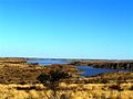
The Hardap Dam is the largest dam in Namibia . He dams the fish river . The dam is located a few kilometers northwest of Mariental .
Due to the construction of the 860 m long and almost 40 m high barrier structure, the fish river is dammed over a length of 30 kilometers and now covers an area of 28.7 km² as a lake. The dam was completed in 1962. The storage space contains around 294.5 million cubic meters of water and supplies the surrounding farms and Mariental with fresh water. The dam is of great importance for agriculture. They created an irrigation area in which fruit and vegetables can be grown on a large scale. In addition, the Hardap Dam is the center of the Hardap Recreation Area - a recreational area and tourist attraction.
At the beginning of February 2020, the Hardap Reservoir reached the lowest water level in its history with a filling volume of just six percent.
gallery
View of the Hardap dam

View of the dam from the east

Bird's eye view of the Hardap Dam

Hardap dam lock


Web links
Individual evidence
- ↑ Hardap never that empty before. Namibia Weather Network, February 4, 2020.