Harsberg (Hainich)
| Harsberg | ||
|---|---|---|
|
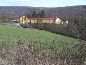
The primeval forest life camp on the Harsberg |
||
| height | 409.5 m above sea level HN | |
| location | Thuringia ( Germany ) | |
| Mountains | Hainich | |
| Coordinates | 51 ° 4 ′ 40 " N , 10 ° 22 ′ 13" E | |
|
|
||
| rock | Shell limestone | |
| particularities | Military base in the GDR era, now the “Urwald-Life Camp” youth hostel, the hillside was the launch site for gliders, now for paragliders | |
The Harsberg is a mountain one kilometer east of Lauterbach , in the north of the Wartburg district in Thuringia .
The Harsberg is located on the west side of the Hainich and, with the unwooded steep slope on the west side, offers an area that has been used for gliding and similar sports since the 1930s. The building complex, which is now used as a youth hostel, was built during the Nazi era and was used militarily as a training location for the border troops during the GDR era. The mountain has been partially cleared since the Middle Ages, an old road leads over the Ihlefeld to the ridge of the Hainich and on to the east side of the mountain. There the road ends at Kammerforst and Weberstedt in the Unstrut-Hainich district . A section that is now paved leads to the Harsberg Youth Hostel.
Individual evidence
- ↑ Official topographic maps of Thuringia 1: 10,000. Wartburgkreis, district of Gotha, district-free city of Eisenach . In: Thuringian Land Survey Office (Hrsg.): CD-ROM series Top10 . CD 2. Erfurt 1999.

