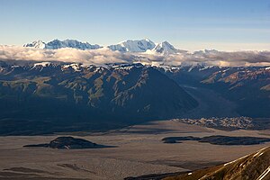
Hawkins Glacier (Alaska)
| Hawkins Glacier | ||
|---|---|---|
|
On the right in the picture the lower end of the Hawkins Glacier |
||
| location | Alaska (USA) | |
| Mountains | Elias chain | |
| Type | Valley glacier | |
| length | 34 km | |
| Exposure | South southwest | |
| Altitude range | 3200 m - 500 m | |
| width | ⌀ 2 km | |
| Coordinates | 61 ° 10 ′ N , 141 ° 57 ′ W | |
|
|
||
| drainage | Chitina River → Copper River | |
The Hawkins Glacier is located in the western Elias chain in Alaska ( USA ).
geography
The Hawkins Glacier's nutrient zone is on the southwest flank of Mount Bona . The glacier flows over a distance of 34 km in a south-southwest direction to the Chitina River . University Peak is on its eastern flank . The average width is 2 km. The lower end of the glacier is about 500 m above sea level . The catchment area of the Hawkins Glacier covers about 260 km². To the east it borders on that of the Barnard Glacier .
Web links
Commons : Hawkins Glacier - Collection of Images, Videos, and Audio Files

