Hawks Nest
| Hawks Nest | |||||||
|---|---|---|---|---|---|---|---|
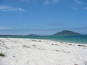
 View from Winda Woppa (Jimmi's Beach) to the Yacaaba Peninsula |
|||||||
|
|||||||
|
|||||||
|
|||||||
|
|||||||
|
|
|||||||
[[Category: Location in New South Wales ]]
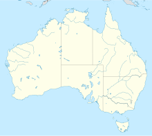
Hawks Nest is a town in the Great Lakes Council in the state of New South Wales in Australia . It lies on the Tasman Sea and is connected to the neighboring village of Tea Gardens by the Singing Bridge .
geography
location
Hawks Nest is bordered by the Myall River to the west, the large natural harbor Port Stephens to the south, the Tasman Sea to the east and the Myall Lakes National Park to the north . The village is located about 220 km north of Sydney and is connected to the Pacific Highway via the Singing Bridge and an approximately 12 km long road .
Hawks Nest is an elongated village with a total length of 16.5 km and an average width of 1.7 km. In the south it includes the uninhabited Yacaaba Peninsula (the highest point of which is 210 meters above sea level) and the populated Winda Woppa Peninsula . Jimmy's Beach and Bennett's Beach are located on the Tasman Sea .
climate
Hawks Nest is located on the northern edge of Australia's temperate climate zone and already shows a tendency towards a subtropical climate. The mean monthly temperatures fluctuate between 8.4 ° C (July) and 27.3 ° C (January). The place is on the edge of an extensive wetland (the Myall Lakes) and has a relatively high annual precipitation for Australia of 1351.2 mm, which is evenly distributed over the seasons.
history
Hawks Nest was first settled in 1865. The place name comes from a large tree, which is a popular nesting place of hawks ( Hawks was) and was used as a navigation point.
The early settlers used the Myall Lakes river and lake system to ship wood. Areas of activity such as wood processing, boat building, agriculture, fishing and mining were added later. With the decline of the timber industry in the late 1880s, the population also fell sharply.
In 1921 the first settlement areas in Hawks Nest and Tea Gardens were publicly designated. A ferry service between the two places began operating in 1928. However, it wasn't until the beginning of commercial sand mining in the area in the 1960s that the two places began to gain importance again. Tourist roads were built and in 1974 the Singing Bridge replaced the ferry service.
tourism
Today Hawks Nest has a population of 1,200. The most important source of income is now tourism . The beaches, a golf course, the proximity to the Myall Lakes National Park and the good fishing opportunities play a central role here.
A small colony of koalas also lives in the village. Close to the Singing Bridge is the Jean Shaw Koala Reserve , a koala sanctuary that is part of a biotope network with the Myall Lakes. The koala population is classified as endangered according to the Threatened Species Protection Act 1995 of the country New South Wales and today comprises only eleven or twelve individuals.
Hawks Nest was the family vacation home of former Australian Prime Minister John Howard for twenty years until he abandoned it in 1998 due to media distress.
Web links
Individual evidence
- ↑ a b Australian Bureau of Statistics : Hawks Nest ( English ) In: 2016 Census QuickStats . June 27, 2017. Retrieved January 26, 2020.
- ↑ Hawks Nest. (No longer available online.) Spatial Information exchange, New South Wales Department of Lands, archived from the original August 18, 2011 ; accessed on April 7, 2009 . Info: The archive link was inserted automatically and has not yet been checked. Please check the original and archive link according to the instructions and then remove this notice.
- ↑ Climate statistics for Nelson Bay. Australian Bureau of Meteorology, accessed April 7, 2009 .
- ^ A b c Narelle Marr: European History of the Great Lakes District. Great Lakes Council, 1993, archived from the original January 4, 2009 ; accessed on April 7, 2009 .
- ↑ Hawks Nest and Tea Gardens Endangered Koala (Phascolarctos cinereus) population. (PDF; 446 kB) Approved NSW Recovery Plan, Department of Environment and Conservation (New South Wales), July 2003, p. 9 , accessed on April 4, 2009 .
- ↑ Popular Walks in The Great Lakes. (No longer available online.) Great Lakes Tourism, archived from the original on May 4, 2009 ; accessed on April 6, 2009 . Info: The archive link was inserted automatically and has not yet been checked. Please check the original and archive link according to the instructions and then remove this notice.
- ↑ Nicola Berkovic: Howard ponders holiday return. (No longer available online.) The Australian , December 27, 2007, archived from the original on December 29, 2007 ; accessed on April 6, 2009 . Info: The archive link was inserted automatically and has not yet been checked. Please check the original and archive link according to the instructions and then remove this notice.

