
Heder Quellen
| Heder Quellen | ||||
|---|---|---|---|---|
 Source pond of the Heder |
||||
| location | ||||
| Country or region | Paderborn district ( North Rhine-Westphalia ) | |||
| Coordinates | 51 ° 39 ′ 14 " N , 8 ° 36 ′ 2" E | |||
| height | approx. 101 m above sea level NHN | |||
|
||||
| geology | ||||
| Mountains | Paderborn plateau | |||
| Source type | Karst springs | |||
| rock | limestone | |||
| Hydrology | ||||
| River system | Rhine | |||
| Receiving waters | Heder → Lippe → Rhine → North Sea | |||
| Bulk | 1900 l / s | |||

Coordinates: 51 ° 39 ′ 14 ″ N , 8 ° 36 ′ 2 ″ E
The Heder sources in North Rhine-Westphalia Paderborn district are in Salzkottener district Upsprunge lying karst springs of the 11.8 km long lip -Nebenflusses Heder . After the Pader springs, they form the second strongest headwaters in North Rhine-Westphalia.
location
The Hederquelleich is located at an altitude of around 101 m above sea level. NHN in the southern part of Upsprunge, about 200 meters south-east of St. Petrus Church. It is located about 6.5 kilometers northeast of Geseke , 8.5 kilometers west of Borchen and about 6 kilometers northwest (as the crow flies) of Niederntudorf . Above the spring pond there are further spring outlets , one of which is only a few meters away from Hederbornstraße . The Heder leaves the headwaters as a 9 meter wide river towards Salzkotten.
Source description


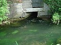
The source area consists of 18 Heder springs (according to other sources, 20 Heder springs, 4 of which are layered and 16 barrier springs), 13 of which are fed with alpine water. The Alme water-bearing springs are karst springs, the water of which comes to a large extent from seepage from the Alme in the karst subsoil between Brenken and Wewelsburg . In this area, the Alme often falls completely dry in summer. The Alme water then covers a distance of 7 km and takes about 23-30 hours. It then reappears in the Heder Quellen, as the water there accumulates on the "Emscher Mergel", a water-impermeable layer.
The pouring of all karst springs (and layer springs from shallower depths) together fluctuates between 500 and 5000 liters per second. The average discharge is 1,900 liters per second and the temperature of the springs fluctuates between 6 and 11 degrees. Several karst springs have extremely strong piles, including 3 karst springs, which come to light under the farms in the headwaters. These are (like the village of Upsprunge) built "on the springs". Another very strong spring is the top spring near Hederbornstrasse.
A networked water system was created in the headwaters, which finally flows into a spring pond, in which further overflowed springs emerge. the Heder splits here into two arms, one of which drives a historic mill wheel and - like the other, receives water from other springs on the Heder Island. After 250 m, the two arms of the spring merge and form an approx. 9 m wide river.
In 2006, the Hederquell area was redesigned, including a treading pool fed by spring water. In addition, information boards were set up at the sources in May 2008.

The upper heavily pouring spring
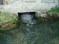
The middle heavy pouring spring
The lower, heavily pouring spring


Traffic and walking
South and east on Heder headwaters past runs Heder Bornstraße . A footpath runs directly through the source area, via which, among other things, a historic mill wheel and a treading basin in the source area can be reached.
literature
- Landscape guide of the Westphalian Heimatbund: The Paderborn plateau ; Ludwig Maasjost; Aschendorff publishing house bookstore; 1962