
Hetta

Hetta [ 'hɛtːɑ ] ( North Sami Heahttá ) is the capital of the Enontekiö municipality in Finnish Lapland .
Hetta is located on the shores of Lake Ounasjärvi in the southern part of Enontekiös at the intersection of the road from Palojoensuu and the road from Kautokeino in Norway . Around 800 of the 2000 inhabitants of the municipality live here. In Hetta you will find the municipal administration, the Enontekiös church, the most important services, the Enontekiö local history museum, the Fjell-Lapland nature and cultural center run by the Finnish forest authority ( Metsähallitus ) and several tourist businesses. The enontekiö airport is located seven kilometers west of Hetta. Hetta is the starting point of a 55 km long hiking trail through the Pallas-Yllästunturi National Park .
The first Finnish new settlers settled in Hetta around 1700. The name is said to go back to an abbreviation of Hietaniemi . Hietaniemi, a village in Ylitornio , was the hometown of the new settler Heikki Heikinpoika, who came to Hetta in 1694. Hetta remained a small and insignificant place until it was decided in the middle of the 19th century to move the church from Palojoensuu to Hetta. In 1907 the first road connection to Hetta was completed. Hetta was largely destroyed by German troops in the Lapland War in 1944 and rebuilt after the war.
photos
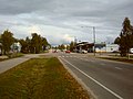
The main street of Hetta

Enontekiö Church


Web links
Coordinates: 68 ° 23 ' N , 23 ° 37' E