Hindenburghöhe
| Hindenburghöhe | ||
|---|---|---|
|
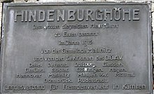
Monument on the Hindenburghöhe |
||
| height | 2315 m above sea level A. | |
| location | Carinthia , Austria | |
| Mountains | Ankogel Group | |
| Dominance | 0.25 km → Liesgelespitz | |
| Coordinates | 47 ° 0 '36 " N , 13 ° 9' 24" E | |
|
|
||
The Hindenburghöhe ( 2315 m above sea level ) is the southernmost tip of a short mountain range of the Ankogel group . It is located directly north of Mallnitz and is one of the local mountains of the place. Just north of the Hindenburghöhe is the Liesgelespitz ( 2408 m above sea level ), the highest elevation of the tributary, which, however, is hidden from Mallnitz by the Hindenburghöhe.
history
The original name of the Hindenburghöhe was Liskelesspitze .
In 1915, the Hanover section of the German and Austrian Alpine Club (DuÖAV) applied to the Mallnitz community to rename the Liskelesspitze to Hindenburghöhe in recognition of Paul von Hindenburg . With the approval of the Mallnitz municipal council, the renaming was decided. A stone monument was erected on a pre-summit in 1923, on which a memorial plaque for Hindenburg, which still exists today, was installed two years later. The text of the plaque reads:
| HINDENBURGHÖHE Named in honor of the great victorious military leader in 1915 by the Mallnitz community and the sections of the D.Ö.AV Celle. Detmold. Duisburg. To water. Gmuend. Goslar. Goettingen. Hagen. Hanover Mallnitz Minden i / W. Möllntal. Osnabrück. Rudolstadt. Regional association for tourism in Carinthia |
When members of the Duisburg section of the DuÖAV laid a wreath in 1926, they and representatives of Carinthia made "a pledge for the great German fatherland". With this in mind, Leopold Lackner wrote in a commemorative publication by the Hanover Alpine Club section in 1935 after the National Socialists came to power: “May the Hindenburghöhe be a symbol of German strength and intransigence, a place of pilgrimage for German mountain hikers, a monument to the close alliance between Germany and Austria. May all hikers who climb to the Hindenburghöhe take the silent vow up at the monument in the spirit of the great dead of Tannenberg to contribute to the unity of the German people. "
The Hindenburghöhe and the way it is dealt with is a testament to the early nationalistic orientation of the Alpine clubs, which campaigned for the integration of Austria into the German Reich well before the Nazi seizure of power in Germany in 1933 and the annexation of Austria in 1938.
Today only the tip is called Hindenburghöhe and the highest point of the ridge bears the historical name, now in the spelling Liesgelespitz .
tourism
The ascent to the Hindenburghöhe usually takes place from the Tauern Valley via the Wittener Weg (AV hiking trail 138). The walking time from Mallnitz is about 3½ to 4 hours. The path is relatively steep; Over a length of approx. 4.5 km, a height of a good 1100 m is overcome.
Alternatively, the Mindener Jubiläumsweg (AV-Wanderweg 137) also leads from the Tauerntal from the Stockingerhütte located at about 1300 m (stop of the hiking bus) to the Hindenburghöhe, whereby the Liesgelespitz has to be crossed before reaching the Hindenburghöhe.
The Hindenburghöhe can be reached in half an hour's walk from the unmanaged Mindener Hütte on the Tauernhöhenweg .
supporting documents
- ↑ Glantschnig 2011, p. 86
- ^ Heidi Rogy: Tourism in Carinthia - From the educational trip to mass tourism. Klagenfurt 2002, p. 231.
- ^ Leopold Lackner: Mallnitz. In: 50 Years of the Hanover Alpine Club Section. Hanover 1935, p. 38 f.
- ↑ Topographic map of the Federal Office for Metrology and Surveying (BEV)
literature
- Erich Glantschnig: Mallnitz (series alpine history in a nutshell ). Oesterreichischer Alpenverein, Innsbruck 2011, pp. 86–87. ( online ).


