Hinterstockensee
| Hinterstockensee | ||
|---|---|---|

|
||
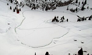
| Hinterstockensee in winter, seen from the Stockhornbahn | ||
| Geographical location | Canton Bern | |
| Drain | underground to Wildebach → Simme | |
| Islands | an island | |
| Data | ||
| Coordinates | 607 776 / 170518 | |
|
|
||
| Altitude above sea level | 1595 m | |
| surface | 6 ha | |
| Maximum depth | 18 m | |
The Hinterstockensee is a lake below the Stockhorn in the area of the Swiss municipality Erlenbach in the Simmental in the canton of Bern .
The Hinterstockensee lies at 1595 m above sea level. M. in a rock basin of a Kars on the south side of the Stockhorn. It is embedded in the Couches-Rouges-Kern (red marl slate of the Upper Cretaceous ) of the Hinterstockensee-Mulde named after it . This syncline is located between Schneeloch-Solhorn-Gewölbe and Walper-Schuppenzone and continues from Hinterstockensee, Lasenberg , Nüschleten to Steinig Nacki . Because of its flysch occurrence, it is also known as Flyschmulde (after Roland Umiker).
The diameter of the Hinterstockensee is about 300 meters, its area 6 hectares. The outflow of the lake is underground. The water flows under 40 meters of rocks and emerges as Wildenbach after about eight hours in the Klusi (1300 m).
An unnamed rocky peninsula ( 46 ° 41 '6.2 " N , 7 ° 32' 21.9" O ) on the western shore of the lake background Stock gives the lake through the formation of two bays a heart-shaped surface shape.
The lake can be reached with the Stockhornbahn (Chrindi station). It is a destination for hobby fishermen. A hiking trail leads to Oberstockensee 1.5 km to the west (also Vorderstockensee , 1665 m). The two lakes are connected to each other by a tunnel. The small high-pressure storage power plant Klusi has been using the water of the lakes to generate energy since the 1940s, and the system was renewed in 1994/1995.
Web links
- Hinterstockensee on schweizersee.ch
Individual evidence
- ↑ Geoserver of the Swiss Federal Administration ( information ) with connected water network VECTOR25
- ^ A b David Andrist, Walter Flükinger, Albert Andrist: Das Simmental zur Steinzeit. Stämpfli & Cie Bern, 1964, p. 106.
- ↑ Geological Guide of Switzerland. Swiss Geological Society, B. Wepf & cie., 1934, p. 602.
- ^ Announcements from the Natural Research Society in Bern. Naturforschende Gesellschaft in Bern, BF Haller, 1956, p. 226.
- ↑ Walter Holzer: Renewal / expansion of the small hydropower plant Klusi. in TEC21 , Volume 128 (2002), Issue 36: Wasserkraft.
